
Lake of the Ozarks is one of the most complex recreational lakes in the entire United States. It does not look like a simple oval or rectangle on a map. It looks like a giant tree with a long trunk and dozens of branches spreading in every direction. It winds, splits, bends, and doubles back on itself across more than 1,100 miles of shoreline.
For a first-time visitor on the water, that complexity can feel genuinely disorienting. Everything starts to look the same. Coves blend together. The open water stretches in multiple directions. You are not sure if you are heading toward your destination or away from it.
That is exactly why mile markers at Lake of the Ozarks exist. They are the lake’s navigation system. Once you understand how they work, everything on the water makes sense. You can find any location, describe any spot to another boater, and navigate this massive lake with real confidence.
This guide explains the mile marker system completely. By the end, you will read mile markers like someone who has been on this lake for years.
Why Lake of the Ozarks Uses a Mile Marker System
Lake of the Ozarks was created in 1931 when Bagnell Dam was completed across the Osage River. The Union Electric Company built the dam to generate hydroelectric power. The resulting reservoir became one of the largest man-made lakes in the United States at the time of its creation.
The lake does not have street addresses. There are no intersections, no block numbers, and no street signs on the water. Early boaters, property owners, and marina operators needed a consistent way to describe locations on the lake. A mile marker system was developed to solve that problem. It became the universal reference system that everyone on Lake of the Ozarks uses today.
The system is deeply embedded in the culture of this lake. Locals do not say they live near the southern end of the lake. They say they live at mile marker 8. A marina does not advertise its general location. It advertises its mile marker. When a charter captain talks about where Party Cove is, they give you a mile marker. When a lakeside bar like Shady Gators or Backwater Jacks gives directions, mile markers are part of that conversation. Understanding this system is not just useful for navigation. It is the language of Lake of the Ozarks.
How the Mile Marker Numbering System Works
The mile marker system at Lake of the Ozarks starts at Bagnell Dam and counts outward from there. This is the single most important thing to understand about the system. Everything radiates from the dam.
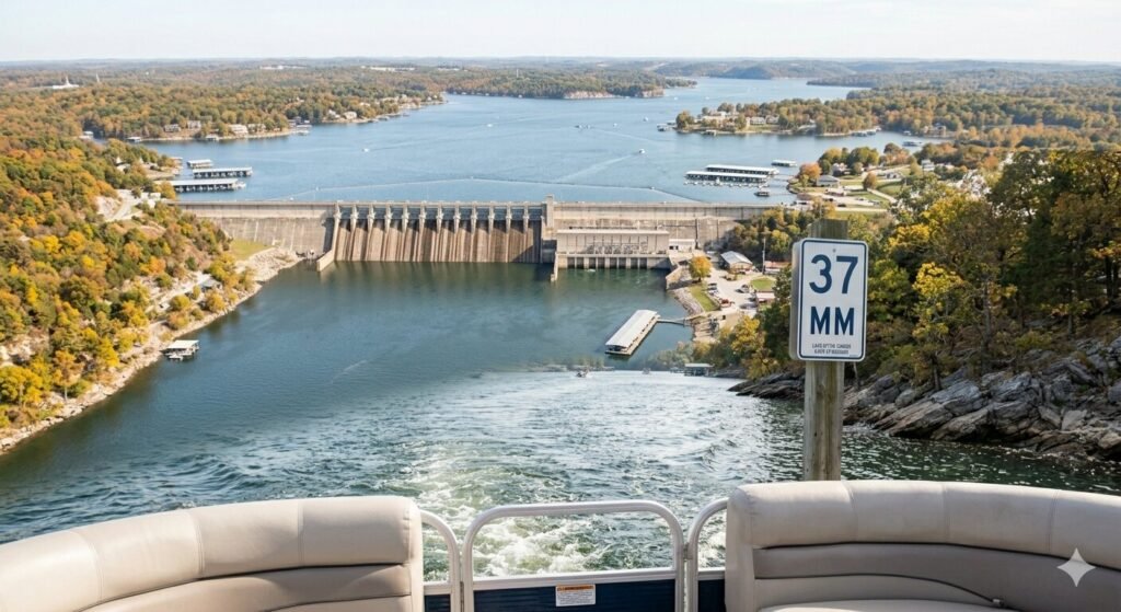
Mile Marker 0 is located at Bagnell Dam itself. This is the lower end of the lake, closest to the dam structure. As you travel away from Bagnell Dam and up the lake toward its upper arms and tributaries, the mile marker numbers increase. The further you get from the dam, the higher the number.
The main channel of the lake follows the original path of the Osage River. This is the deepest and widest section of the lake. It runs from Bagnell Dam northward and eventually splits into two major arms. The primary arm continues up the original Osage River path. The secondary arm follows the Niangua River tributary. Both arms have their own mile marker sequences extending from where they branch off the main channel.
The main channel reaches into the mid-40s in terms of mile markers before it branches. The Osage Arm and the Niangua Arm each extend further with their own numbering that continues from the split point. The Niangua Arm stretches from approximately Mile Marker 42 at its entrance and runs north. The upper Osage Arm extends into the upper lake regions past the 40s.
The numbering on the main channel gives you an instant sense of where you are relative to the rest of the lake. Low numbers mean you are near Bagnell Dam and the lower lake. The areas near Mile Marker 1 through 10 include the commercial hub near the dam, the Lake Ozark city area, and the high-traffic lower lake zone. Mid-range numbers like Mile Marker 20 through 30 put you in the busy mid-lake region near Osage Beach. Higher numbers push you into the quieter upper lake territory.
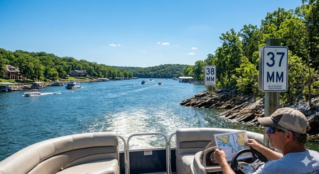
Mile markers are posted on signs visible from the water. They appear on both shorelines at regular intervals. The signs are typically white with black numbers and are mounted on poles or structures along the bank. They are designed to be readable from a boat on the water. As you cruise the main channel, you can track your position by watching these markers appear on the shoreline.
The Main Channel vs. the Arms | Understanding the Full System
The mile marker system is more than just a single line of numbers from the dam outward. The lake branches into multiple arms and each arm has its own mile marker context. Understanding how the main channel relates to the arms is what takes your navigation from basic to confident.
The main channel is the backbone of the lake. It carries the highest boat traffic. It has the deepest water. It connects the lower lake near Bagnell Dam to the mid-lake hub at Osage Beach and beyond. Every major marina, every well-known destination, and every high-traffic area on Lake of the Ozarks has a main channel mile marker reference even if it sits in a cove or off the primary channel.
Coves and inlets are referenced by the mile marker at their entrance on the main channel. If a cove opens off the main channel at Mile Marker 18, boaters refer to that as the Mile Marker 18 cove. You do not need a separate addressing system for coves. The mile marker at the cove entrance is the reference point everyone uses.
The Niangua Arm branches off the main channel in the upper lake area. This arm extends northward into a quieter and less trafficked part of the lake. It has its own identity and character. Boaters who know the Niangua Arm well navigate it by mile marker references that begin where the arm diverges from the main channel. If you are planning to explore the Niangua Arm, knowing the approximate mile marker at the entrance tells you where to turn off the main channel.
The Grand Glaize Arm and other significant inlets also have their positions described by main channel mile markers. Grand Glaize is a large arm near the Osage Beach area. It contains significant development including the famous Grand Glaize Bridge which is a major Lake of the Ozarks landmark. Boaters approaching Grand Glaize use the main channel mile marker at its entrance as the reference point.
Understanding this branching structure is what allows you to communicate your position on the lake with precision. You can tell a friend, a captain, a marina, or the Missouri State Water Patrol exactly where you are by naming the nearest mile marker and specifying whether you are on the main channel, in a cove, or in one of the arms. That level of precision is what the mile marker system is built to deliver.
Key Landmarks and Their Mile Markers at Lake of the Ozarks
Knowing the mile marker system works best when you anchor it to real places you actually want to find or recognize. Here are the key landmarks on Lake of the Ozarks and their approximate mile marker positions. These references make the system immediately practical and real.
Bagnell Dam sits at Mile Marker 0. It is the defining structure of the lake. The dam is visible from the water and unmistakable. If you are near the dam, you are at the very beginning of the mile marker sequence. The area around Mile Marker 0 through 3 includes the dam strip, the Ha Ha Tonka State Park bluffs visible across the water, and the lower lake commercial area.
The Lake Ozark city area sits roughly in the Mile Marker 1 through 5 range. This is a high-traffic zone with significant development on both shorelines. Multiple marinas, waterfront businesses, and heavy recreational boat traffic define this section of the lake.
Osage Beach is the commercial heart of Lake of the Ozarks. It sits in the vicinity of Mile Marker 19 through 28 along the main channel. Osage Beach is where you find the highest concentration of marinas, waterfront restaurants, resort hotels, shopping, and entertainment. The Grand Glaize Arm branches off in this general area. If someone tells you they are docked somewhere in Osage Beach, they are in this mile marker range.
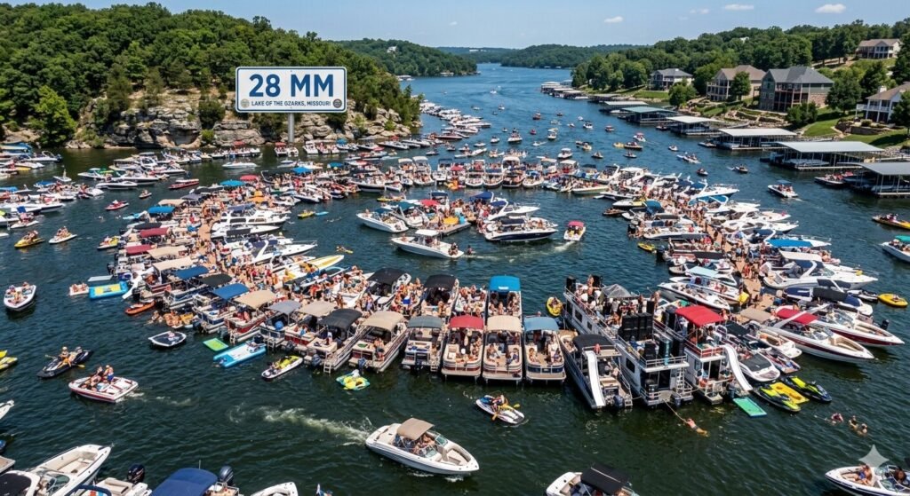
Party Cove is one of the most famous locations on any lake in the United States. It sits near Mile Marker 28 on the main channel. Party Cove is a large open cove where boats raft together on summer weekends to socialize in the water. It draws hundreds of boats on peak summer days. Knowing that Party Cove is at approximately Mile Marker 28 lets you navigate directly to it without confusion.
Shady Gators is a beloved lakeside bar and entertainment venue. It sits near Mile Marker 21 on the main channel. It is accessible by boat with dock space available for charter guests. Backwater Jacks is another iconic lakeside destination positioned in the mid-lake area. These establishments are standard reference points in conversations about mid-lake navigation.
Hurricane Deck sits further up the lake in the upper mid-lake area. The bluffs and scenic stretches around Mile Marker 37 through 42 in this vicinity are among the most photographically stunning sections of the entire lake. The dramatic rock bluff formations and wooded shoreline in this area make it a favorite destination for scenic cruising and overnight anchoring.
Gravois Mills sits in the upper lake region toward the higher mile markers in the upper Osage Arm. This quieter section of the lake is characterized by lower boat traffic and more natural undeveloped shoreline. Boaters who want solitude and calm anchoring consistently head toward the upper lake mile markers.
Camdenton and the area around the Niangua Arm entrance sit in the upper lake mile marker range. Camdenton is a significant town near the lake with marina access and services for boaters exploring the upper lake sections.
How to Use Mile Markers Practically While on the Water
Reading mile markers is one thing. Using them effectively in real-time navigation is another. Here is how experienced boaters on Lake of the Ozarks put the system to work throughout a day on the water.
Before you leave the dock, identify the mile marker of your starting marina. Write it down or note it in your phone. This is your home base number. Every navigation decision you make during the day is relative to that number. If you are launching from a Mile Marker 22 marina and you want to reach Party Cove at Mile Marker 28, you know you are heading further up the lake and the markers will count up as you go in the right direction.
While underway, watch both shorelines for mile marker signs. They appear on both sides of the channel at regular intervals. You do not need GPS to track your general position on Lake of the Ozarks. The mile markers give you a continuous real-time position reference simply by reading the signs as you pass them. If you see Mile Marker 25 on the shoreline, you know exactly where you are on the main channel without any electronic device.
When communicating your position to others, always state the nearest mile marker and which side of the lake or which arm you are in. A message that says we are anchored in a cove just past Mile Marker 31 on the right heading toward the upper lake is a complete and precise location description. The recipient of that message can find you on any Lake of the Ozarks map or chart without ambiguity.
For emergency communication with Missouri State Water Patrol, mile markers are the fastest way to describe your location. If you need assistance on the water, giving the nearest mile marker immediately tells the patrol where to direct resources. Time matters in water emergencies. Being able to say clearly that you are at Mile Marker 17 on the main channel eliminates confusion and speeds response.
When planning an itinerary, mile markers let you estimate travel time and distance. A captain familiar with Lake of the Ozarks can tell you approximately how long it takes to cruise from Mile Marker 5 to Mile Marker 28 based on vessel speed and traffic conditions. That planning capability makes your day on the water more efficient and more enjoyable because you are not guessing at how long each leg of the trip will take.
Common Navigation Mistakes and How to Avoid Them
Lake of the Ozarks catches unfamiliar boaters off guard in specific and predictable ways. Knowing these common mistakes helps you avoid them before they become a problem on the water.
The most common mistake is confusing the arm numbering with the main channel numbering. The Niangua Arm has its own character and the mile marker sequence in the upper lake arms can feel disconnected from the main channel numbers if you do not understand the branching structure. Before exploring any arm of the lake, note the main channel mile marker at the point where you turn off. That reference point is your anchor for getting back to the main channel correctly.
Assuming all coves are accessible at all water levels is another error. Lake of the Ozarks water levels fluctuate seasonally. A cove that has 10 feet of depth in spring may have significantly less water in a drought year. Checking current lake level data from the Army Corps of Engineers and using your vessel’s depth finder when exploring unfamiliar coves prevents running aground.
Losing track of your direction on the main channel happens more than you might expect on a lake this complex. The channel bends repeatedly and after several turns in unfamiliar territory, some boaters lose their sense of whether they are heading toward lower or higher mile markers. The simple fix is to note the direction the mile marker numbers are moving as you travel. If the numbers are going up, you are moving away from Bagnell Dam toward the upper lake. If they are going down, you are heading toward the dam and the lower lake.
Relying entirely on electronic GPS without learning the mile marker system is a mistake that leaves you vulnerable if your device loses signal or battery. Lake of the Ozarks has areas where cell signal is inconsistent. A boater who understands the mile marker system can navigate confidently without any device. It is always the right backup when technology fails.
How Mile Markers Help You Plan a Yacht Charter at Lake of the Ozarks
For guests booking a charter with Yacht Rental Lake Ozark, understanding the mile marker system directly improves how you plan and discuss your itinerary. It is the vocabulary your captain uses to communicate the plan for the day.
When you tell your captain you want to spend time near Party Cove, they know immediately that you are talking about the Mile Marker 28 area. When you express interest in scenic bluffs and quieter water, they know to head toward the upper lake mile markers in the 35 to 42 range. When you want to be close to waterfront restaurants and lakeside bars, they plan around the Osage Beach mile marker corridor.
A captained charter with Yacht Rental Lake Ozark gives you the advantage of a professional who has logged extensive hours navigating this lake by its mile marker system. Your captain knows every significant destination, every notable cove entrance, and every section of the lake by its position in the marker sequence. You do not need to become a Lake of the Ozarks navigation expert to have the best possible day on the water. But understanding how the system works makes you a better partner in planning the experience you actually want.
Mile markers also help you understand the scope of what a full charter day covers. A cruising route from Mile Marker 5 to Mile Marker 30 and back covers a substantial portion of the lake. A focused day near the Osage Beach corridor between Mile Marker 20 and 28 gives you deep access to the most activity-rich section of the lake. Knowing the mile markers helps you make informed decisions about how to spend your time on the water.
Frequently Asked Questions
Where does the mile marker numbering start at Lake of the Ozarks?
The mile marker numbering starts at Mile Marker 0 at Bagnell Dam. This is the lower end of the lake closest to the dam structure. Numbers increase as you travel away from the dam and up the lake toward the upper arms and tributaries.
How do I find mile marker signs on the lake?
Mile marker signs are posted along both shorelines of the main channel at regular intervals. They are white signs with black numbers mounted on poles or structures along the bank. They are designed to be visible from a vessel on the water. Watch both shorelines as you cruise the main channel and the signs will appear consistently as you move through each mile of the lake.
What mile marker is Party Cove at Lake of the Ozarks?
Party Cove sits near Mile Marker 28 on the main channel of Lake of the Ozarks. It is one of the most well-known landmarks on the lake and a standard reference point in conversations about mid-lake navigation.
What mile marker is Osage Beach at Lake of the Ozarks?
Osage Beach spans the main channel from approximately Mile Marker 19 to Mile Marker 28. This section of the lake contains the highest concentration of marinas, restaurants, resorts, and waterfront entertainment on the entire lake.
Does the mile marker system cover the arms of Lake of the Ozarks?
Yes. The main channel has its own mile marker sequence. The major arms including the Niangua Arm and the upper Osage Arm branch off the main channel at specific mile marker positions and extend further with their own navigation context. Coves and inlets are typically referenced by the main channel mile marker at their entrance.
How do I use mile markers to communicate my position in an emergency?
State the nearest mile marker number clearly and specify which section of the lake you are in such as the main channel, a specific cove, or a named arm. For example, saying we are at Mile Marker 24 on the main channel near Osage Beach gives Missouri State Water Patrol or other boaters a precise location for response.
Can I navigate Lake of the Ozarks using only the mile marker system without GPS?
Yes. Experienced boaters on Lake of the Ozarks navigate confidently using only the mile marker system in combination with their knowledge of the lake’s layout. Reading mile marker signs from the water and tracking your position relative to known landmarks is a reliable navigation method. GPS is a useful tool but the mile marker system works independently of any electronic device.
What is the highest mile marker on Lake of the Ozarks?
The exact highest mile marker depends on which arm of the lake you are navigating into. The main channel extends into the mid-40s before branching. The Niangua and upper Osage arms extend further with mile markers continuing into the upper 40s and beyond in some sections. The specific upper limit varies by the arm and the current water level of the lake.
Do captains on yacht charters at Lake of the Ozarks use the mile marker system?
Yes absolutely. The mile marker system is the primary navigation language on Lake of the Ozarks. Every professional captain operating on this lake navigates by mile markers. At Yacht Rental Lake Ozark, our captains communicate itinerary plans, location references, and destination discussions in mile marker terms. Understanding the system helps you participate more actively in planning your charter day.
Navigate Lake of the Ozarks with Confidence
The mile marker system is not complicated once you see how it is organized. It starts at Bagnell Dam at Mile Marker 0. Numbers increase as you move away from the dam. The main channel carries the primary sequence. The arms branch off and extend further. Coves are referenced by the mile marker at their entrance. Major landmarks have well-known mile marker positions that every experienced boater on this lake knows by memory.
That system gives you everything you need to navigate Lake of the Ozarks competently. You can find Party Cove at Mile Marker 28. You can cruise the Osage Beach corridor between Mile Marker 19 and 28. You can head toward the scenic bluffs and quieter coves of the upper lake in the Mile Marker 35 to 42 range. You can communicate your exact position to anyone on this lake without confusion.
The best way to put this knowledge to work is to get on the water. Yacht Rental Lake Ozark offers captained charters staffed by professionals who know every mile of this lake. Whether you are exploring the lake for the first time or returning for another season, our team helps you experience the best of what Lake of the Ozarks offers from Mile Marker 0 all the way to the upper arms.
Reach out today to book your charter. The lake is waiting and now you know exactly how to read it.