
Lake of the Ozarks is a massive lake. Its main channel stretches 92 miles from Bagnell Dam all the way to the western end near Warsaw. Most casual boaters and yacht renters spend their time in the lower portion of the lake, roughly between Mile Marker 0 and Mile Marker 30. But if you are planning to push further west toward the Hurricane Deck area, there is one question every tall vessel operator needs to answer before heading out.
Can your yacht clear the Hurricane Deck Bridge?
This is not a question most boaters think about on a typical lake day. Standard pontoon boats and mid-size rental vessels have no issue. But tall yachts, flybridge cruisers, large houseboats, and vessels with elevated upper decks face a real consideration at this bridge. Getting this wrong is not just an inconvenience. It can cause serious damage to your vessel and create a dangerous situation on the water.
This guide covers everything you need to know. What the Hurricane Deck Bridge is, why it matters for tall vessels, how to determine if your yacht can safely pass, and what your options are if it cannot.
What Is the Hurricane Deck Bridge and Where Is It
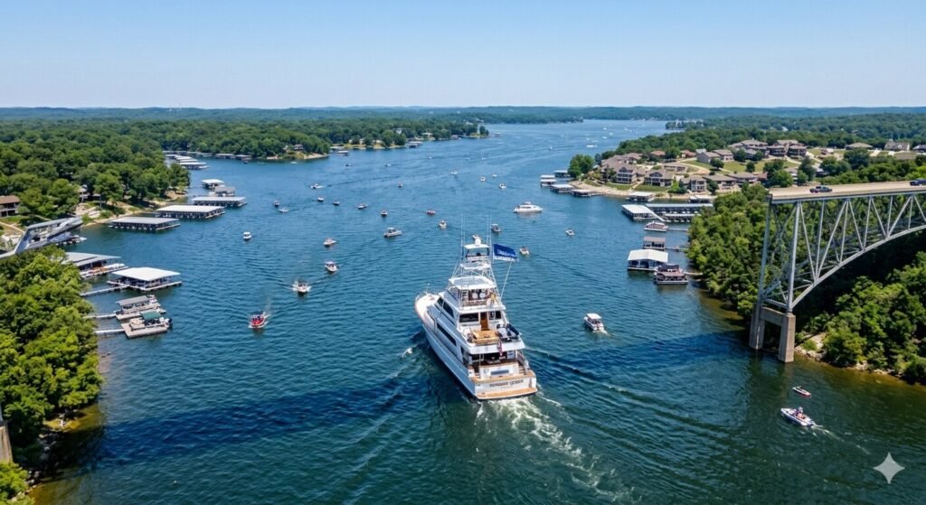
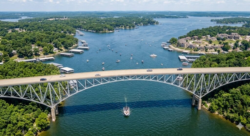
The Hurricane Deck Bridge carries Missouri Route 5 across the Osage Arm of Lake of the Ozarks. It is located in the unincorporated community of Hurricane Deck in Camden County, roughly in the mid-to-upper section of the main channel, connecting the communities of Laurie and Camdenton on either side of the lake.
The original Hurricane Deck Bridge was built in 1936 and was one of the most iconic structures on the entire lake. It was an upside-down truss design, meaning the support structure sat below the road deck rather than above it. This gave drivers spectacular views of the lake as they crossed, and it became one of the most photographed and distinctive features on the water for decades.
That original bridge was eventually replaced. The new Hurricane Deck Bridge was completed in 2014, built by the Missouri Department of Transportation at a cost of approximately 32 million dollars. The replacement is a modern plate girder bridge, 2,260 feet long, supported on large diameter drilled shaft foundations that reach down through 85 feet of water into bedrock. It is built to carry traffic for the next 100 years. The new structure has two 12-foot lanes and seven-foot shoulders, making it wider and safer than its predecessor. But the plate girder design sits lower over the water in certain areas compared to the tall clearance of the old upward-arching truss design, which is exactly why tall vessel operators need to pay attention.
Why Bridge Clearance Matters for Tall Yachts
Bridge clearance is the vertical distance between the water surface and the lowest point of the bridge structure above. For most recreational boats, this number is irrelevant. A standard pontoon rental sits low and passes comfortably under almost any bridge on the lake. But as vessel size increases, so does the height of the structure above the waterline.
A typical center console or pontoon boat might stand 6 to 9 feet above the water at its highest point. A flybridge yacht or cruiser can reach 14 to 18 feet or more above the waterline when you account for the upper helm station, radar arch, antennas, and any hardtop or canopy structure. Large houseboats with second-floor decks can be even taller. These vessels require significantly more vertical clearance to pass safely under a bridge without contact.
On Lake of the Ozarks specifically, bridge clearance information is not officially published in a centralized or easily accessible format the way it is for coastal or federally regulated waterways. The Army Corps of Engineers and standard marine chart apps like Navionics do not consistently list bridge clearance heights for the bridges on this lake. This makes it the operator’s responsibility to research the specific bridge before approaching it in a tall vessel. Arriving at a bridge and discovering mid-approach that your yacht will not fit is one of the most preventable problems in boating, yet it happens every season somewhere on this lake.
How to Know if Your Yacht Can Clear the Hurricane Deck Bridge
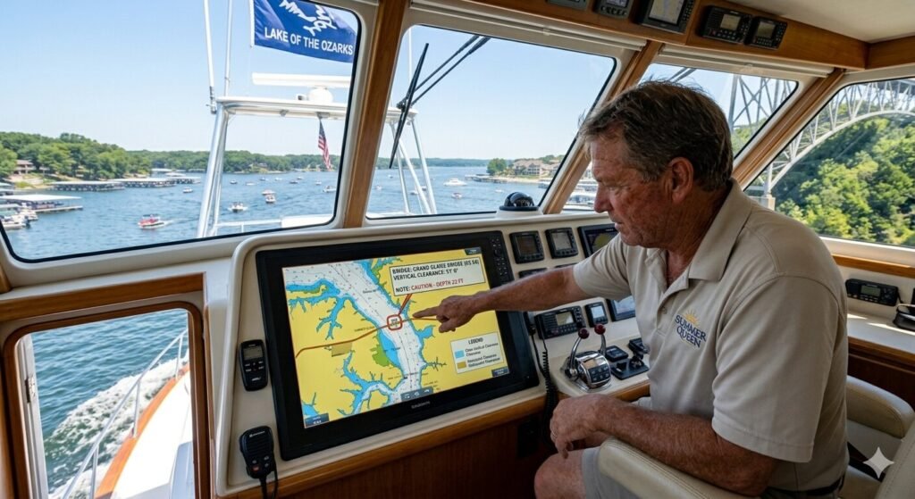
The key step before attempting any bridge crossing in a tall yacht is knowing your vessel’s air draft. Air draft is the total height of your boat measured from the waterline to the highest fixed point on the vessel. This includes radar arches, antennas, hardtops, flybridge railings, and any other structure that cannot be lowered or removed. If you are renting a yacht, your rental company should be able to tell you the air draft of the specific vessel you are booking.
Once you know your vessel’s height, the next step is finding the actual clearance at the Hurricane Deck Bridge. Because this information is not officially published for recreational boaters on Lake of the Ozarks, you need to go directly to the best local sources. The most reliable approach is to contact MoDOT (Missouri Department of Transportation) directly and ask for the vertical clearance data for the Highway 5 Hurricane Deck Bridge over the Osage Arm. MoDOT has engineering records for the bridge and can provide this measurement. You can also contact the Camden County office or local marina operators in the Hurricane Deck and Sunrise Beach area who have practical, firsthand knowledge of what has and has not passed safely under that bridge.
Additionally, lake level matters. Lake of the Ozarks operates at a normal pool elevation of 660 feet above mean sea level, and the lake rarely varies by more than 5 feet in either direction. When lake levels are higher than normal pool, there is less clearance under every bridge on the lake. When levels are below normal pool, clearance increases. If you are planning a tall vessel trip past Hurricane Deck, check the current lake level through Ameren Missouri’s website before your departure. A difference of even two to three feet in lake level can be the margin between a safe crossing and a dangerous one.
Practical Steps Before Taking a Tall Yacht Past Hurricane Deck
Planning ahead is everything when it comes to tall vessel navigation on Lake of the Ozarks. There is no on-water moment of truth that you want to face without having done your homework. Here is the preparation process every tall yacht operator should follow before heading toward Hurricane Deck.
Start by measuring your vessel accurately. Do not estimate. Use an actual measurement from the waterline to the absolute highest fixed point on your yacht. Include everything: the radar dome, the VHF antenna, any hardtop edge, flybridge railing, or decorative structure. Even a few inches can matter when bridge clearance is tight. If you are renting a yacht and the rental company does not have this number readily available, ask them to measure before your trip.
Contact the rental company and ask specifically about bridge clearance. Any reputable yacht rental company at Lake Ozark will know whether their vessels are appropriate for the upper main channel near Hurricane Deck. They deal with this question regularly and can tell you upfront if your chosen vessel is too tall for that section of the lake. If they cannot answer this question confidently, that itself tells you something important about the depth of their lake knowledge.
Call a local marina near Hurricane Deck or Sunrise Beach. These are the people who see vessels pass under that bridge regularly. They know from real experience what heights work and what heights do not. A five-minute phone call to a marina in that area can save you from a serious problem on the water. They can also tell you about current lake levels and any seasonal conditions that might affect clearance.
Check Ameren Missouri’s current lake level data. Ameren operates and maintains Bagnell Dam and publishes current lake level readings. Before any trip involving bridge clearance concerns, check this number and compare it to the bridge’s design elevation. If the lake is running high, add caution. If it is below normal pool, you may have additional clearance to work with.
Plan your approach slowly and carefully. Even after doing all of your research, when you actually approach the Hurricane Deck Bridge in a tall vessel, do it at idle speed. Approach from a distance where you have a clear view of the bridge span ahead of you. Watch your GPS chart plotter or lake map to know exactly where you are. If anything looks uncertain, stop well before the bridge, assess the situation, and make the call from a safe distance rather than from directly beneath the structure.
What to Do If Your Yacht Cannot Clear the Bridge
Not every tall yacht will be able to safely pass under the Hurricane Deck Bridge. This is not a failure of planning. It is simply the reality of operating a large vessel on an inland lake with fixed bridge structures. If you determine in advance that your vessel’s air draft exceeds the available clearance, you have a few solid options.
The most common solution is to stay in the lower section of the lake. The vast majority of yacht rentals, day trips, and cruising destinations on Lake of the Ozarks are located between Bagnell Dam and approximately Mile Marker 30. Party Cove, Osage Beach, the Grand Glaize Arm, the Gravois Arm, dozens of waterfront restaurants, and all of the most popular summer destinations are within this zone. You never need to go near Hurricane Deck to have a full, extraordinary day on the water.
Another option is to choose a lower-profile vessel for trips that require passage past Hurricane Deck. If your itinerary genuinely requires access to the upper main channel west of the bridge, book a vessel with a lower air draft. Standard pontoon boats and open-deck vessels have no issue with this bridge. Save the tall flybridge cruiser for the lower lake where clearance is never a concern.
If you are on a private owned tall vessel and need to reach a destination on the other side of Hurricane Deck, the only water route is through the bridge. In this case, the preparation described above is essential. Know your height, confirm the clearance, check the lake level, go slow, and do not proceed if any uncertainty remains. An approach that feels uncertain should always be treated as a definitive stop.
The Broader Picture of Bridge Navigation on Lake of the Ozarks
Hurricane Deck is not the only bridge on the lake that tall vessel operators need to think about. The Lake of the Ozarks has several major bridges crossing different parts of the main channel and its arms. Each has different clearance heights, and not all of them are friendly to tall vessels.
The Grand Glaize Bridge where US Highway 54 crosses into the Grand Glaize Arm in Osage Beach is notably low. Boaters with sailboats and tall vessels consistently note that this bridge has limited clearance and is often not passable for vessels with significant air draft. The Community Bridge, formerly a toll bridge connecting Horseshoe Bend with Shawnee Bend, has much more generous clearance and is generally not a problem for typical rental yachts.
The broader lesson across all of these structures is the same. Know your vessel’s height before you approach any bridge. Lake of the Ozarks is a large, winding, complex body of water with multiple bridge crossings at different points. As you plan longer trips toward the western or upper sections of the main channel, bridge clearance is one of the key navigational planning questions every tall vessel operator must ask and answer before leaving the dock.
For yacht renters specifically, this planning happens before you even choose your vessel. Tell your rental company what parts of the lake you intend to visit. They will recommend the right vessel for your planned route and flag any bridge clearance concerns before you are committed to a boat that cannot safely complete the trip you have in mind.
Tips for Safe Tall Vessel Navigation on Lake of the Ozarks
A few simple habits will make navigation in any tall vessel on this lake significantly safer, not just at Hurricane Deck but anywhere bridges come into the picture.
Always approach bridges at idle speed. Full-throttle approaches to bridge spans leave no room for error. Slow down well before the bridge comes into view and keep your speed minimal all the way through until you are fully clear on the other side.
Have a second person on watch. When passing under any bridge in a tall vessel, having a second set of eyes from the bow or an elevated position on the boat gives you early warning of any potential contact risk. Communication between the helm and the watch position keeps the approach controlled and calm.
Use a GPS chart plotter with depth and structure data. A good marine GPS shows you bridge locations, helps you track your position relative to the span, and gives you advance notice of any structure in your path. Apps like Navionics or dedicated Lake of the Ozarks chart plotters are widely used by boaters on this lake and add a meaningful layer of navigational confidence.
Never try to squeeze under a bridge if you are unsure. If your research suggests the clearance is marginal and conditions are not ideal, do not attempt the crossing. The cost of turning back and finding an alternative plan is zero. The cost of bridge contact to your yacht is enormous and potentially life-threatening to passengers. When in doubt, stop.
Frequently Asked Questions
What is the clearance height of the Hurricane Deck Bridge for boats?
The Hurricane Deck Bridge on Lake of the Ozarks does not have an officially published vertical clearance for recreational boaters in the same way federally regulated waterways do. The best approach is to contact MoDOT directly for engineering data, or to call local marinas near Sunrise Beach and the Hurricane Deck area who have firsthand knowledge of what vessels have and have not passed safely. Always factor in the current lake level, which affects clearance at all bridges on the lake.
Can a rental yacht from Lake Ozark reach the Hurricane Deck Bridge area?
Yes, the Hurricane Deck Bridge is accessible by water on the main Osage channel. However, whether a specific rental yacht can pass under it depends entirely on the vessel’s air draft compared to the available bridge clearance. Before booking, ask your rental company about the air draft of the vessel you are considering and whether it is appropriate for travel in the upper main channel.
What is air draft and why does it matter for this bridge?
Air draft is the total height of your boat measured from the waterline to the highest fixed point on the vessel. This includes the flybridge, radar dome, antennas, hardtop, and any other structure that extends upward. It is the critical measurement when determining whether a vessel can safely pass under a fixed bridge span. If your air draft exceeds the bridge clearance, the vessel cannot pass without risking contact.
Does lake level affect bridge clearance on Lake of the Ozarks?
Yes, significantly. Lake of the Ozarks operates at a normal pool elevation of 660 feet above mean sea level. When the lake rises above normal pool, clearance under every bridge on the lake decreases. When it drops below normal pool, clearance increases. Checking the current lake level through Ameren Missouri’s published data before a trip involving bridge clearance planning is an essential step.
What happens if my yacht is too tall to clear the Hurricane Deck Bridge?
If your vessel cannot safely pass under the bridge, your options are to stay in the lower section of the lake, which covers the vast majority of popular destinations, or to use a lower-profile vessel for trips requiring access to the upper main channel west of Hurricane Deck. Attempting to force a crossing when clearance is uncertain or insufficient is dangerous and should never be done.
Are there other bridges on Lake of the Ozarks that tall yachts need to worry about?
Yes. The Grand Glaize Bridge in Osage Beach is known to be low, and boaters with tall vessels or sailboats consistently report insufficient clearance for passage into the Grand Glaize Arm. The Community Bridge generally has much more generous clearance. Every bridge crossing on a tall vessel requires advance research and slow, cautious approach.
Who can I call to get reliable bridge clearance information for Hurricane Deck?
MoDOT is the authoritative source for engineering clearance data on the Hurricane Deck Bridge since it carries Missouri Route 5. Local marinas in the Sunrise Beach and Hurricane Deck area are also excellent practical resources, as their staff regularly see what vessels can and cannot pass. Your yacht rental company should also have this knowledge if they serve customers who travel the full length of the main channel.
Is it safe to navigate the upper main channel past Hurricane Deck in a standard rental pontoon?
Standard rental pontoons and low-profile deck boats are generally much lower in air draft than flybridge yachts or houseboats and typically do not have clearance issues at the Hurricane Deck Bridge. That said, always confirm with your rental company before heading into the upper channel, and follow the same slow approach habits at any bridge regardless of vessel size.
Final Thoughts
Crossing the Hurricane Deck Bridge on a tall yacht at Lake of the Ozarks is not something you figure out on the water. It is something you plan for before you leave the dock.
Know your vessel’s air draft. Confirm the bridge clearance through reliable local sources. Check the current lake level. Approach slowly. And if any doubt remains, do not proceed.
The Lake of the Ozarks has over 92 miles of main channel and 1,150 miles of shoreline. The majority of the best experiences this lake offers are well within the lower channel, far from any bridge clearance concern. But for those who want to explore the full length of this magnificent waterway, doing it safely starts with understanding the structures you will encounter along the way.