
The Lake of the Ozarks is not your typical lake. It does not sit in a simple oval or rectangle like most inland reservoirs. It winds, twists, and branches across central Missouri in a shape so serpentine that locals gave it a fitting nickname, the Magic Dragon. With over 1,150 miles of shoreline and a surface area of roughly 54,000 acres, this is one of the largest man-made lakes in the entire United States.
For first-time visitors and even returning boaters who have only explored part of the lake, understanding how it is laid out makes a huge difference. The lake is organized around a central spine called the main channel, and branching off from that spine are several distinct arms, each with its own character, its own mile marker system, and its own appeal.
This guide breaks down every arm of the Lake of the Ozarks so you can plan smarter trips, navigate with confidence, and get the most out of every day on the water.
How the Lake Is Structured and Why the Arms Matter
Lake of the Ozarks was created in 1931 when Bagnell Dam was built across the Osage River in central Missouri. The dam flooded the entire Osage River valley along with several of its tributaries, and those flooded tributary valleys became the arms of the lake you see today. The main channel follows the original path of the Osage River, and the arms follow the paths of the rivers and creeks that once fed into it.
The main channel, known as the Osage Arm, runs approximately 92 miles from Bagnell Dam at its northeastern end all the way to Truman Dam near Warsaw at the western end. This is the backbone of the entire lake. Every arm branches off from this central spine. The four primary arms are the Gravois Arm, the Grand Glaize Arm, the Big Niangua Arm, and the Little Niangua Arm. Each one was formed by a different tributary feeding into the original Osage River.
The reason this structure matters so much for boaters is simple. Each arm has its own mile marker system that starts at zero where the arm meets the main channel. So when you hear someone say they are at the 6 Mile Marker on the Gravois Arm, that means they are 6 miles up the Gravois from where it connects to the main channel. Without understanding which arm someone is on, a mile marker number means very little on a lake this large and complex.
Every marina, restaurant, resort, vacation rental, and waterfront business on the lake uses this combined system of main channel markers and arm markers to communicate location. Learning to read it is the single most important navigation skill you can develop before your first day on the water.
The Main Channel | The Osage Arm
The Osage Arm is the primary artery of the entire lake. It is the widest, longest, and most traveled section of water at Lake of the Ozarks. Mile Marker 0 begins at Bagnell Dam and the numbers increase as you travel south and west along this channel. The most developed, most visited, and most active stretch of the entire lake runs from approximately Mile Marker 0 to Mile Marker 25.
This lower section of the main channel is where you will find the Bagnell Dam Strip, the cities of Lake Ozark and Osage Beach, the highest concentration of waterfront restaurants and bars, the majority of marinas and fuel docks, and many of the lake’s most famous events including the Lake of the Ozarks Shootout powerboat races. The Horseshoe Bend peninsula wraps around the channel between roughly Mile Markers 3 and 10. The Osage Beach area sits between approximately Mile Markers 14 and 21, and this stretch is considered the commercial and social heart of the entire lake.
As you travel west beyond Mile Marker 25 and further up the Osage Arm, the lake gradually becomes quieter and less developed. The shoreline transitions from dense resort and residential development into more rural, forested terrain. By the time you reach Mile Markers 40 to 60 near the Hurricane Deck community and beyond, the lake has a noticeably different feeling. It is wider in some sections, quieter overall, and the boat traffic thins significantly compared to the busy lower channel. This upper section is excellent for fishing, quiet cruising, and exploring the more natural, undisturbed side of Lake of the Ozarks.
The Grand Glaize Arm
The Grand Glaize Arm is the most famous and most visited of all the lake’s tributary arms. It branches off the main Osage channel at approximately Mile Marker 19, right where the Grand Glaize Bridge carries US Highway 54 over the water in Osage Beach. When you pass under that bridge heading southeast, you have entered the Grand Glaize Arm. The arm runs approximately 16 miles from its junction with the main channel before narrowing into a stream near the upper end.
This arm is home to one of the most iconic destinations on the entire lake. Party Cove, officially known as Anderson Hollow Cove, is located within Lake of the Ozarks State Park at approximately the 4 Mile Marker of the Grand Glaize Arm. On peak summer weekends, over 3,000 boats gather here in what is widely described as the largest floating party in the country. It is a cultural institution of the lake and a bucket list destination for boaters from across the Midwest.
Beyond Party Cove, the Grand Glaize Arm is known for its calm, protected waters that are particularly well suited to tubing, water skiing, and relaxed anchoring in coves. The arm is also home to two of the lake’s only public swimming beaches, both located within Lake of the Ozarks State Park. Public Beach 1 sits at approximately the 12 Mile Marker on the Grand Glaize Arm, and Grand Glaize Beach is nearby. Both offer sandy shoreline swimming in a park setting, a rare find on a lake where most shoreline is privately owned. The arm has several public boat ramps, and McCubbin’s Point near the 8 Mile Marker on the Glaize Arm offers a free launch option for boaters.
The Grand Glaize Arm is also one of the top largemouth bass fishing areas on the lake, with the arm’s fishing docks, cove structures, and deeper channel sections holding fish throughout the season. Whether you are heading to Party Cove for a social day, exploring the state park’s stunning natural scenery, or anchoring in a quiet cove for an afternoon swim, the Grand Glaize Arm delivers some of the lake’s most memorable experiences.
The Gravois Arm
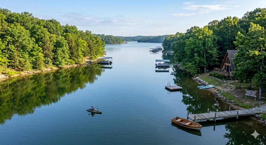
The Gravois Arm connects to the main Osage channel on the northeastern side of the lake, joining at approximately Mile Marker 6 on the main channel. This places its entrance very close to the dam and to the busy lower channel near Lake Ozark. Despite this proximity to one of the lake’s busiest zones, the Gravois Arm itself has a very different personality from the main channel. It is notably quieter, more sheltered, and significantly less trafficked than the stretches of open water just miles away.
The arm runs approximately 10 miles from its junction with the main channel before reaching the town of Gravois Mills and narrowing further upstream. The Coffman Beach Access at the 2.6 Mile Marker on the Gravois Arm provides a well-marked public launch point accessible via Route Y from Eldon. The Gravois Mills Access at the 10.1 Mile Marker on the arm provides a second public launch option for boaters entering from that end of the water.
The Gravois Arm has long been considered one of the best bass fishing areas on the entire lake. Its deep channels, rocky banks, and dock-lined shoreline create ideal habitat for largemouth and spotted bass throughout the season. The arm is also one of the oldest developed sections of the lake, so its shoreline is dotted with private boat docks that provide classic fishing structure. For families who want to enjoy tubing or anchoring without the heavy wake and traffic of the main channel, the Gravois Arm offers a significantly calmer environment. Coves branching off the arm are protected and quiet, making them popular for swimming stops and relaxed afternoon anchoring.
The arm’s position near the lake’s lower end also makes it easy to combine a Gravois Arm excursion with a main channel day. You can cruise the active main channel in the morning and duck into the quieter Gravois Arm for a peaceful afternoon, all within a short boat ride.
The Big Niangua Arm and Little Niangua Arm
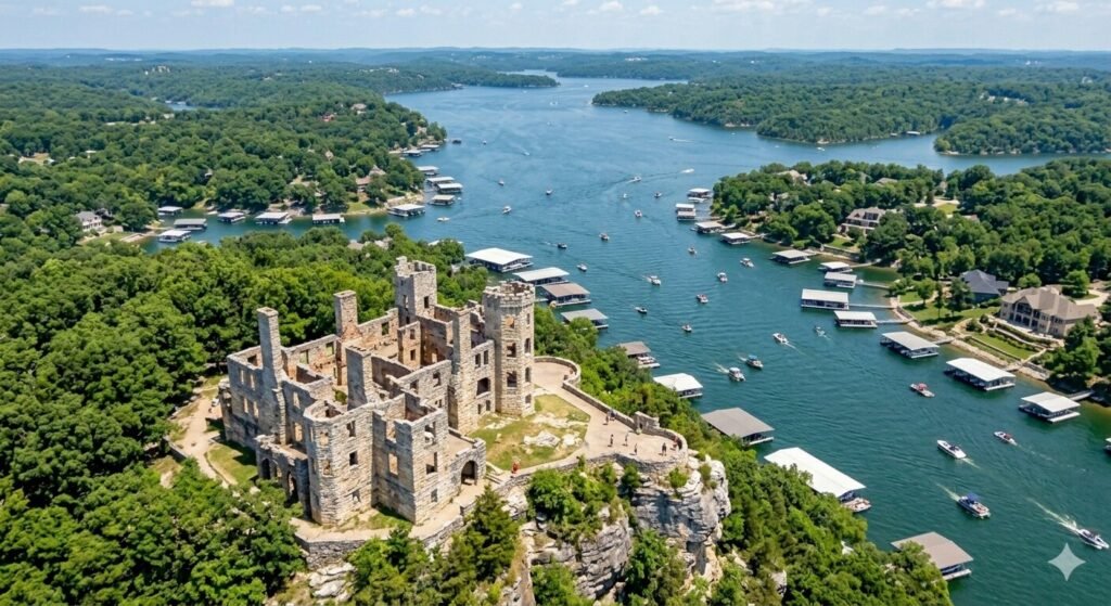
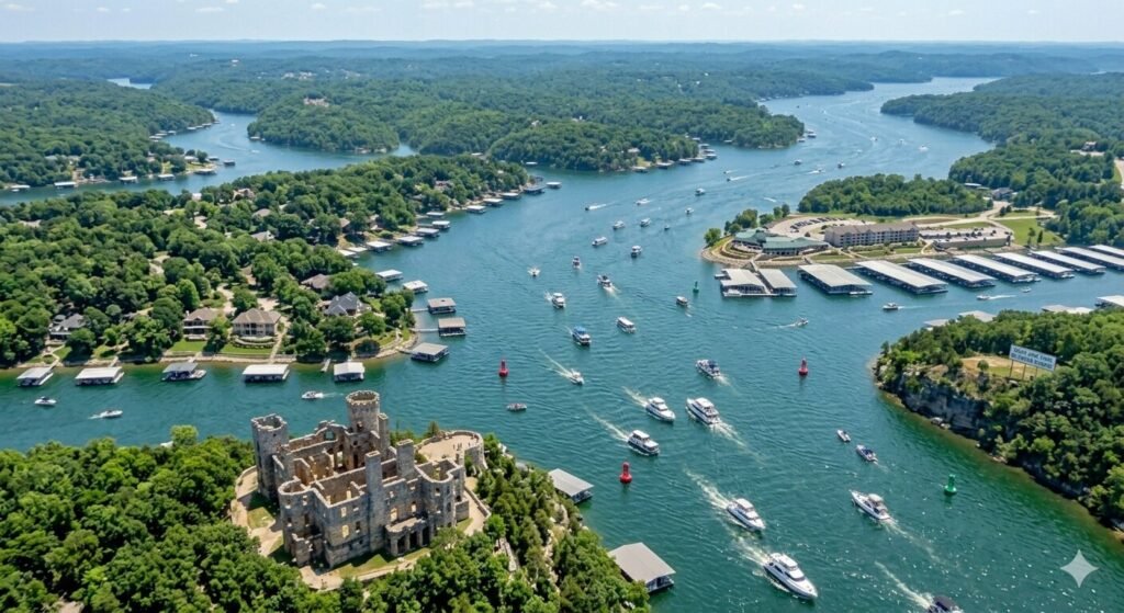
The Niangua Arms are the most scenic and least commercialized of all the lake’s tributary arms. There are two of them, the Big Niangua Arm and the Little Niangua Arm, both branching from the southwestern section of the main Osage channel. The Big Niangua joins the main channel at approximately Mile Marker 43, and the Little Niangua connects further west in the same general area. Both arms were formed by the flooding of the Niangua River and its tributaries when Bagnell Dam was completed.
The Big Niangua in particular is often described as the most naturally dramatic part of the entire Lake of the Ozarks. It winding resembles a large river more than a typical reservoir arm, with a narrower channel, fewer major coves, and a shoreline that is far less developed than the main channel or Grand Glaize Arm. The geological features along the Big Niangua are extraordinary. Ha Ha Tonka State Park sits on the bluffs above this arm, featuring a 70-foot-wide natural bridge, a 500-foot-long collapsed sinkhole called the Colosseum, dramatic recess caves, and the ruins of a stone castle perched on a cliff directly overlooking the water. Boaters who pull into the coves below these bluffs and look up at the stone ruins rising above the trees are treated to a genuinely spectacular view that feels completely unlike anything on the busier sections of the lake.
The Niangua Arms are renowned among fishing enthusiasts as some of the most productive crappie and catfish water on the entire lake. Crappie in particular are abundant in the coves and points of the Niangua Arms, and anglers who know this water well rarely need to travel elsewhere during peak fishing seasons. The arm is also one of the better areas for finding white bass during seasonal feeding runs. The overall atmosphere is tranquil and rural. This is the part of the lake that feels furthest from the summer crowds and closest to what this wild Ozark landscape must have looked like before the dam was ever built.
The Little Niangua Arm shares many of these same qualities. It is narrower and shorter than the Big Niangua but equally quiet and scenic. Both arms are best explored by boaters who are comfortable navigating narrower channels and who want a very different experience from the main channel bustle.
How to Navigate the Arms Using Mile Markers
Once you understand the structure of the lake, navigating between the main channel and the arms becomes straightforward. The key is remembering that each arm has its own independent mile marker system that restarts at zero where the arm connects to the main channel.
So if you are cruising the main Osage channel and want to head to Party Cove on the Grand Glaize Arm, you travel along the main channel to approximately Mile Marker 19 and pass under the Grand Glaize Bridge. From that point, you are now on the Grand Glaize Arm and the markers restart at zero. Party Cove is at approximately 4 Mile Markers up the Grand Glaize from that junction.
Similarly, if you depart the main channel to explore the Gravois Arm, you look for the junction at approximately Mile Marker 6 on the main channel. Once you enter the arm, the mile markers restart from zero at the entrance. The Coffman Beach boat ramp is at approximately the 2.6 Mile Marker on this arm, and Gravois Mills is near the 10 Mile Marker.
Always carry a current lake map when exploring the arms. The Lake of the Ozarks Convention and Visitors Bureau offers free downloadable maps showing all mile markers on both the main channel and the arms. Marine GPS apps like Navionics also display the lake’s structure and help you identify junctions, coves, and your position on the water in real time. On a lake this large and branched, knowing exactly where you are at any moment is not just helpful, it is essential for safety.
Choosing the Right Arm for Your Day on the Water
Each arm of the Lake of the Ozarks suits a different kind of boating day. Understanding these differences helps you match the arm to your group’s goals and preferences before you ever leave the dock.
The main Osage channel in the lower lake section is ideal for boaters who want waterfront dining, live events, maximum energy, and the full social experience of lake life. The concentration of restaurants, fuel docks, and marinas in the Mile Marker 5 to 20 range is unmatched anywhere else on the lake. If your group wants to dock and dine at multiple spots, cruise past the Bagnell Dam Strip, or watch the Shootout race from the water, this is your zone.
The Grand Glaize Arm is ideal for groups heading to Party Cove, families wanting access to the state park beaches, or anyone looking for calmer water that is still easily reachable from the busy main channel. It strikes a great balance between activity and accessibility, and its public swimming beaches give families a place to anchor that few other arms can match.
The Gravois Arm suits boaters who want a quieter, more peaceful day without straying far from the main lake. It is close to the lower channel but feels like a different world once you are inside it. Fishing groups, families with young children, and anyone who wants to anchor in a calm cove for the afternoon will feel right at home here.
The Niangua Arms are for boaters who want natural beauty, excellent fishing, and true tranquility. If your group is made up of anglers, nature lovers, or anyone who wants to escape the summer crowds entirely, the Niangua Arms offer an experience that is completely different from the social, high-energy main channel. The state park scenery above the Big Niangua is some of the most stunning anywhere on the lake.
Frequently Asked Questions
How many arms does Lake of the Ozarks have?
Lake of the Ozarks has four primary tributary arms branching off the main Osage channel. They are the Gravois Arm, the Grand Glaize Arm, the Big Niangua Arm, and the Little Niangua Arm. The main channel itself, the Osage Arm, runs 92 miles from Bagnell Dam to Truman Dam and serves as the central spine from which all other arms branch. Each arm has its own independent mile marker system that starts at zero where the arm joins the main channel.
What is the most popular arm on Lake of the Ozarks for boaters?
The Grand Glaize Arm is the most popular and most visited arm on the lake. It is home to Party Cove at the 4 Mile Marker, the only two public swimming beaches on the lake within the state park, and some of the lake’s best bass fishing. Its entrance under the Grand Glaize Bridge at Mile Marker 19 on the main channel makes it highly accessible from the busy Osage Beach area.
Where does each arm of the lake branch off the main channel?
The Gravois Arm connects to the main Osage channel at approximately Mile Marker 6. The Grand Glaize Arm branches off at approximately Mile Marker 19, just south of the Grand Glaize Bridge in Osage Beach. The Big Niangua Arm and Little Niangua Arm both connect to the main channel in the southwestern section around Mile Marker 43 and further west respectively. All arm mile markers restart at zero from their junction with the main channel.
Which arm is best for fishing at Lake of the Ozarks?
Each arm offers excellent but different fishing. The Gravois Arm is widely considered one of the top bass fishing areas on the entire lake, with deep channels and rocky banks that hold largemouth and spotted bass. The Niangua Arms are renowned for crappie and catfish, with the coves and points producing consistent catches throughout the season. The Grand Glaize Arm is good for largemouth bass, particularly around the arm’s dock structures and cove points.
Is Party Cove on the main channel or one of the arms?
Party Cove, officially called Anderson Hollow Cove, is located on the Grand Glaize Arm, not the main channel. It sits at approximately the 4 Mile Marker of the Grand Glaize Arm, within the boundaries of Lake of the Ozarks State Park. To reach it from the main channel, you pass under the Grand Glaize Bridge at Mile Marker 19 and travel approximately 4 miles southeast up the arm.
Can I rent a yacht and explore the different arms of the lake?
Yes. A yacht or pontoon rental from Lake Ozark gives you the freedom to explore the main channel and any of the lake’s arms during your time on the water. Most rental companies are located near the lower main channel and the Osage Beach area, which puts you within easy reach of the Grand Glaize and Gravois Arms. The Niangua Arms require more travel time from the lower lake. For groups who want a guided exploration of the different arms, a captained yacht charter is an excellent choice since the captain handles all navigation.
How do I read mile markers on the arms of the lake?
Each arm has its own mile marker sequence that starts at zero at the point where the arm connects to the main Osage channel. Mile markers on the arms are usually noted with the arm name to avoid confusion, for example 4 Mile Marker Grand Glaize Arm or 10 Mile Marker Gravois Arm. Without the arm designation, a mile marker number is assumed to refer to the main Osage channel. A printed or digital lake map showing all arm mile markers is the most reliable reference tool for navigating between the channels.
Which arm of Lake of the Ozarks is the quietest and most scenic?
The Big Niangua Arm is widely considered the quietest and most naturally scenic arm on the entire lake. It sits furthest from the busy lower main channel, sees significantly less boat traffic than the Grand Glaize or Gravois Arms, and is bordered by dramatic Ozark bluffs, natural caves, and the castle ruins of Ha Ha Tonka State Park. Boaters who make the journey up the Big Niangua consistently describe it as one of the most beautiful and peaceful water experiences on the entire lake.
What is the difference between the Osage Arm and the other arms?
The Osage Arm is the main channel of Lake of the Ozarks. It is the longest, widest, and most traveled section of the lake, running 92 miles from Bagnell Dam to Truman Dam. It is not a tributary arm but the primary body of water from which all tributary arms branch. The other arms, Gravois, Grand Glaize, Big Niangua, and Little Niangua, are narrower, shorter, and each has its own distinct character. The Osage Arm has the highest concentration of development, services, events, and boat traffic on the entire lake.
Final Thoughts
Understanding the arms of Lake of the Ozarks is the foundation of smart, confident boating on this lake. Once you know how the main channel connects to each arm, and what each arm offers, you stop seeing the lake as an intimidating maze and start seeing it as a collection of distinct, explorable destinations.
The Grand Glaize for energy and social life. The Gravois for quiet and fishing. The Niangua Arms for natural beauty and solitude. The main channel for everything in between.
Whether you are renting a yacht for the day or planning a full week on the water, this knowledge gives you the ability to build a trip that perfectly matches what your group is looking for. The lake is big. The variety is extraordinary. And every arm has something worth finding.