
Planning a private charter at Lake of the Ozarks is exciting. But many guests arrive without a clear picture of how the lake is laid out. They hear terms like mile markers, arms, coves, and channels. They see a long, winding map that looks nothing like a typical lake. It can feel confusing at first.
The good news is that Lake of the Ozarks has a very logical system. Once you understand the basics, the map makes complete sense. You can plan your route, identify your favorite stops, and communicate clearly with your captain before your charter even begins.
This guide breaks it all down. We will cover the mile marker system, the main channel, the major arms, cove navigation, depth charts, and no-wake zones. By the end, you will know exactly how to read a Lake of the Ozarks map for your private charter.
Understanding the Shape and Layout of Lake of the Ozarks
Lake of the Ozarks is not a round or oval lake. It is a long, branching reservoir. It was created in 1931 when the Bagnell Dam was built across the Osage River. The dam blocked the river and flooded the surrounding valleys. This created a lake with one main channel and dozens of smaller arms, coves, and inlets branching off in every direction.
The lake stretches over 90 miles from Bagnell Dam at the eastern end to the upper reaches near the dam’s headwaters. If you add up all the shoreline, the lake has over 1,150 miles of coastline. That is more shoreline than the entire state of California’s Pacific Coast. The sheer size of the lake is one reason a map is so important.
When you look at a Lake of the Ozarks map, the first thing you notice is that the lake has a distinct shape. The main body runs diagonally from the dam area toward the northwest. Off this main body, two major arms extend in different directions. The Osage Arm runs to the northwest and is the longer of the two primary branches. The Niangua Arm branches off toward the west. Both arms have their own smaller coves and channels running off them.
Understanding this branching structure is the foundation of reading any Lake of the Ozarks map. Everything else, including mile markers, cove names, and anchorage spots, is built on top of this basic layout.
The Mile Marker System Explained
The mile marker system is the single most important thing to understand when reading a Lake of the Ozarks map. It is the universal reference system used by boaters, marinas, captains, and local businesses across the entire lake.
Mile markers start at zero. Mile marker 0 is located at Bagnell Dam. From there, the numbers increase as you travel up the lake away from the dam. Mile marker 1 is one mile from the dam. Mile marker 10 is ten miles up the lake. The mile markers continue all the way to the upper reaches of the lake near mile marker 92 on the main Osage channel.
The Niangua Arm has its own set of mile markers. They branch off from the main channel around mile marker 28. The Niangua markers start at the junction and increase as you travel further into that arm. When a captain or marina mentions a location, they almost always use the mile marker as a reference point. “We are anchoring near mile marker 45” tells everyone on board exactly where the boat is on the lake.
The lower portion of the lake, from the dam to around mile marker 20, is the most commercially developed stretch. Marinas, restaurants, bars, and resorts line both shores in this area. This is where you find Party Cove near mile marker 5, Shady Gators, Backwater Jacks, and many other well-known destinations. It is also the busiest and most congested stretch of water on the lake.
As you move further up the lake past mile marker 30, the development thins out. By mile marker 50 and beyond, the shoreline becomes more wooded and residential. Traffic drops noticeably. The water gets calmer. Many guests who want a peaceful, relaxing private charter experience prefer the middle and upper sections of the lake for exactly this reason.
Reading Coves and Arms on the Map
Coves are the smaller inlets that branch off the main channel and the major arms. They appear on the map as narrowing pockets of water cutting into the shoreline. Some coves are wide and open. Others are narrow and deep. Understanding how to identify and read coves on the map helps you plan where to stop, swim, or anchor during your charter.
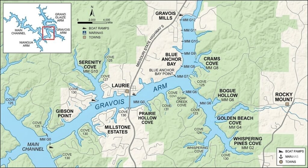
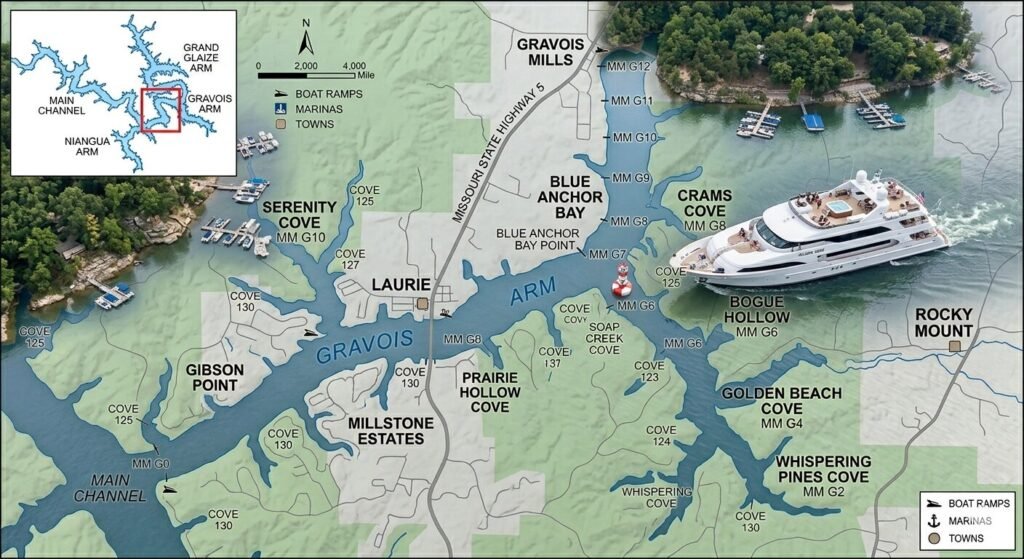
Each cove has a name on most detailed Lake of the Ozarks maps. Some names are official. Others are local nicknames used by longtime boaters. Lynch Hollow, Gravois Arm, Hurricane Deck area coves, and Coffman Cove are examples of named locations that appear on most charts. Knowing the name of a cove makes it much easier to plan your route with your captain in advance.
When reading a cove on the map, pay attention to its entrance width. A wide entrance means boats of all sizes can enter easily. A narrow entrance means only smaller vessels or careful captains can navigate inside. For a 50-foot luxury yacht, your captain will always check the entrance width before heading into any cove. Most maps mark shallow areas with dotted lines or color shading.
The Gravois Arm is one of the most popular destinations for charter guests who want calm water and beautiful scenery. It branches off the main channel around mile marker 55 to 60 and runs for several miles to the southwest. The coves inside the Gravois Arm are well-protected and lightly trafficked. On a detailed map, you can see how the arm narrows as it extends further from the main channel. This narrowing is a visual clue that the water will be calmer and quieter the further in you go.
The Upper Osage Arm begins roughly above mile marker 60 and extends all the way to the upper end of the lake. This is the most remote and peaceful stretch on the entire lake. On the map, it appears as a long, winding channel with wooded shores on both sides. The coves here are deep and well-protected. Many guests who book overnight yacht charters choose to anchor in this area for maximum peace and quiet.
How to Use Depth Charts for Safe Navigation
A standard lake map shows you the shape of the water from above. A depth chart shows you what is happening below the surface. For a private charter, depth information is critical. It tells your captain where it is safe to take a large vessel and where shallow areas must be avoided.
Lake of the Ozarks depth charts use color coding. Dark blue areas represent the deepest water. Lighter shades indicate shallower zones. Green or yellow markings near the shore often indicate areas with less than five feet of water. A yacht of significant size needs at least six to eight feet of water to move safely. Your captain always consults depth information before entering an unfamiliar cove or arm.
The main channel is the deepest part of the lake. Near Bagnell Dam, the lake can reach depths of over 100 feet. As you move further up the lake, the average depth decreases. In the upper arms and remote coves, some areas become quite shallow, especially near the shoreline. Depth charts show these transitions clearly. A smart captain uses them to plan the safest and most efficient route for every charter.
One important thing to look for on a depth chart is submerged hazards. When Lake of the Ozarks was filled in 1931, the flooded valleys contained trees, old roads, and structures. Many of these are still on the lake bottom. Over the decades, most have been cleared from major channels. But in remote upper areas and rarely visited coves, submerged stumps and rocks can still be a concern. Depth charts and local knowledge both help captains avoid these hazards.
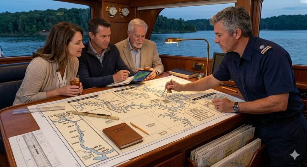
When you review a depth chart with your captain before your charter, focus on three things. First, identify the deepest parts of your planned route. Second, note any shallow areas near your intended swim stops or anchorage spots. Third, mark any caution zones or hazard markers shown on the chart. This preparation makes the on-water experience smooth and worry-free.
No-Wake Zones and Restricted Areas on the Map
Every detailed Lake of the Ozarks boating map includes no-wake zone markings. These are areas where boats must slow their speed. A no-wake speed is typically under five miles per hour. At this speed, the vessel does not produce a disruptive wake.
No-wake zones appear near marinas, boat ramps, swimming beaches, and congested dock areas. On the map, they are usually marked with a dashed boundary line or a specific symbol. Some maps use a small anchor icon to show designated anchorage areas where no-wake rules also apply.
Understanding no-wake zones matters for several reasons. If your captain enters a no-wake zone at speed, it is a legal violation. Missouri State Highway Patrol Water Division actively patrols the lake, especially during summer months. Violations can result in fines. More importantly, high-speed wakes near swimming areas or docked boats cause real damage and create safety hazards.
On your charter, you will pass through several no-wake zones. The marina where you board will almost certainly be inside one. As your captain leaves the dock area and heads toward open water, you will notice the vessel speed up once the zone boundary is cleared. On the way back, the captain will slow down again before re-entering the zone.
Some coves also have informal slow-down expectations even if they are not officially marked as no-wake zones. Local boaters follow a common courtesy rule: slow down when passing anchored boats or swimmers. Your captain will always follow this practice. When reading your map in advance, take note of any areas labeled as swimming beaches or heavily used anchorages. These are places where courtesy speed reductions are standard and expected.
Planning Your Charter Route Using the Map
The real value of understanding a Lake of the Ozarks map comes when you sit down to plan your charter route. Most guests who book a private yacht charter have specific goals. Some want to visit waterfront restaurants and bars. Others want a quiet swim stop far from the crowds. Many want a mix of both.
Start by identifying your departure marina or dock location. This gives you your starting mile marker. From there, work outward on the map to identify the stops you want to make. If you are departing from a marina near mile marker 3, reaching the Gravois Arm at mile marker 55 is a long trip. A 50-foot yacht at cruising speed covers water efficiently, but you still need to factor in travel time. Your captain can give you realistic time estimates for any route.
Next, identify your priority stops. If a swim in a quiet cove is your main goal, mark two or three cove options on the map. Having backups is smart because a cove that looks perfect on paper might be occupied when you arrive. Your captain will always have alternative suggestions ready.
Consider the time of day as part of your route planning. Heading toward busy areas like Party Cove or the lower lake bars is more enjoyable in the early afternoon. Quiet coves and swimming stops are best in the morning or late afternoon when traffic is lower. A well-planned route works with the natural flow of the lake rather than against it.
Finally, share your map plan with your captain before departure. An experienced USCG certified captain at Yacht Rental Lake Ozark knows the lake deeply. They can refine your plan, suggest better alternatives, and flag any areas that might be closed, crowded, or difficult to access with a large vessel on your charter date. This collaboration between guest and captain is what makes a private charter experience truly excellent.
Frequently Asked Questions
What is the mile marker system on Lake of the Ozarks?
Mile markers are numbered reference points that start at zero at Bagnell Dam and increase as you travel up the lake. They are used by all boaters and marinas to identify locations on the lake. Mile marker 0 is at the dam and the numbers go up to around mile marker 92 on the main channel.
Where does the main channel of Lake of the Ozarks run?
The main channel runs from Bagnell Dam at mile marker 0 through the center of the lake toward the northwest. It is the deepest and busiest stretch of water. The Osage Arm and Niangua Arm branch off from this main channel.
What is the Niangua Arm on the lake map?
The Niangua Arm is one of the two major branches of Lake of the Ozarks. It extends westward from the main channel near mile marker 28. It has its own set of mile markers and contains several popular coves and anchorage spots.
How do I find a quiet cove using the map?
Look for narrow inlets that branch off the main channel or the upper arms. Coves with narrow entrances are generally quieter because large boats cannot enter at speed. The further up the lake you go, the more sheltered and peaceful the coves tend to be.
What does a depth chart show and why does it matter?
A depth chart shows the underwater depth across different parts of the lake. Darker colors typically indicate deeper water. Your captain uses depth charts to avoid shallow areas and submerged hazards, especially when entering coves or unfamiliar stretches of the lake.
Are no-wake zones marked on Lake of the Ozarks maps?
Yes. Detailed boating maps of Lake of the Ozarks include no-wake zone markings near marinas, boat ramps, and congested areas. These zones are enforced by Missouri State Highway Patrol Water Division. Your captain knows all active no-wake zones on the lake.
Can I plan my own charter route before booking?
Absolutely. You can review a Lake of the Ozarks map before booking and identify the stops you want to make. Sharing this plan with your captain during booking allows them to refine the route and give you accurate travel time estimates for the day.
What maps are best for planning a Lake of the Ozarks charter?
Detailed nautical charts of Lake of the Ozarks show mile markers, cove names, depth information, and no-wake zones. The Lake of the Ozarks Marine Dealers Association publishes a widely used paper map. Many boaters also use apps like Navionics or Lake Ozark specific GPS chart layers for on-water navigation.
Do I need to understand the map if I have a captain?
You do not need to navigate yourself. Your USCG certified captain handles all navigation. But understanding the map helps you communicate your preferences clearly and plan a route that matches your goals. It also makes the experience more enjoyable because you know where you are on the lake at all times.
Ready to Plan Your Private Charter at Lake of the Ozarks?
Reading a Lake of the Ozarks map is not complicated once you know the system. Mile markers give you location references across 90 miles of water. The main channel, the Osage Arm, and the Niangua Arm form the backbone of the lake. Coves and inlets branch off in every direction. Depth charts keep navigation safe. No-wake zones keep everyone protected.
When you combine this map knowledge with an experienced captain, you get a private charter experience that is smooth, well-planned, and deeply enjoyable. Yacht Rental Lake Ozark connects you with professional captains who know every stretch of this lake. Contact us today to start planning your perfect day on the water.