
One of the best things about the Lake of the Ozarks is that you can experience almost everything it offers without ever leaving the water. The drive between Bagnell Dam and Osage Beach takes only a few minutes by car. But by boat, that same stretch becomes a completely different experience. You get to pass through the heart of the lake, watch the shoreline open up, and enjoy every mile of one of Missouri’s most iconic waterways.
If you are planning a yacht rental at Lake Ozark and want to make the most of your time on the water, this route is one you need to know. This guide covers everything, from understanding the mile marker system to travel time, what you will see along the way, and tips to keep your trip smooth from start to finish.
Understanding the Lake of the Ozarks Before You Cast Off
Before you start plotting your route, it helps to understand how this lake is laid out. Lake of the Ozarks is a large reservoir created by impounding the Osage River. The main channel of the Osage Arm stretches 92 miles from one end to the other, and the lake has roughly 1,150 miles of shoreline in total. That is a massive body of water, and getting your bearings before you leave the dock makes everything easier.
The lake is long and winding in shape, with several arms branching off the main channel. These include the Gravois Arm, the Grand Glaize Arm, and the Niangua arms to the southwest. For the Bagnell Dam to Osage Beach route, you will be traveling primarily along the main Osage channel, which is the central spine of the entire lake.
Bagnell Dam sits at the northeastern end of the lake, where the Osage River is impounded. The city of Osage Beach sits where the lake’s southeastern arm joins the main channel. Knowing this positioning gives you a clear mental picture of the route before you even touch the throttle.
The Mile Marker System | Your Best Friend on the Water
If you are new to Lake of the Ozarks, the mile marker system is the single most important thing to understand. Unlike navigating by street signs or landmarks, this lake uses a numbered reference system along the shoreline that tells every boater exactly where they are at any given moment.
Mile Marker 0 begins at Bagnell Dam, and markers increase as you travel southward up the main Osage arm. Most marinas, restaurants, and vacation rentals identify their location by mile marker. So when a local tells you that a restaurant is at the 18 mile marker, they mean it is 18 miles along the main channel from Bagnell Dam.
On the lake maps, you will notice a series of numbers printed along the waterways. These numbers represent lake mile markers and are used to communicate a location with lake access. When you see a number without any arm designation, it refers to a main channel location. Each arm of the lake has its own separate mile marker system that starts at zero where the arm meets the main channel.
The Osage Beach area sits roughly between mile markers 14 and 21 on the main channel. This stretch is considered one of the best areas for visitors because it offers central access to dining, shopping, attractions, and the lake’s main channel. That means your water journey from Bagnell Dam to Osage Beach covers approximately 14 to 20 miles of open lake water, depending on exactly where you plan to dock in the Osage Beach area.
The Water Route from Bagnell Dam to Osage Beach
Starting your trip at or near Bagnell Dam puts you at Mile Marker 0, the very beginning of the lake’s main channel. From here, you head south along the Osage arm. The channel is wide and well marked in this section. The lake opens up quickly once you clear the dam area, and you will feel the full scale of this reservoir almost immediately.
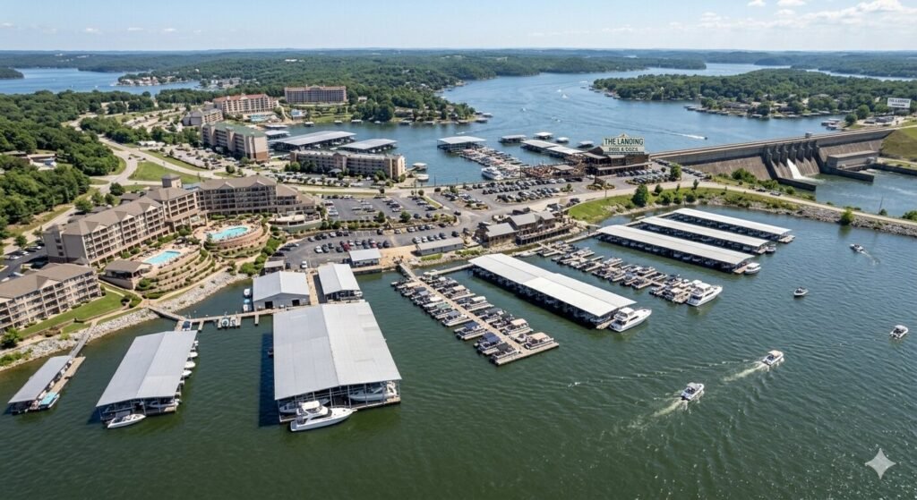
As you leave the dam area, the first several miles take you through the Lake Ozark city zone. The area around Osage Beach and Lake Ozark, roughly between mile markers 10 and 20, is the most developed stretch of the lake. This is where you will find the Bagnell Dam Strip, the majority of the resorts, and the highest concentration of restaurants and shops. This is also where boat traffic picks up significantly on weekends, so keeping your speed sensible and watching for wakes is important during this stretch.
Between mile markers 7 and 10, you will begin passing several well-known marinas and fuel docks. There are gas docks near the 7 mile marker area, which are great for a quick fill-up if you are boating near the Bagnell Dam area, and at around mile marker 7.5, there is an upscale marina offering fuel, pump-out services, and a full-service resort if you want to dock and dine. This section of the route is busy but extremely well served with facilities.
Continuing south along the main channel, you will pass through some of the most scenic and activity-filled water on the entire lake. Coves branch off on both sides. Houseboats and pontoons dot the shoreline. Private docks with boats tied up signal the dense residential and resort development that makes this corridor so lively. By the time you reach the 14 to 21 mile marker range, you have arrived in Osage Beach territory. The Grand Glaize arm branches off to your southeast in this section, and that is where several key docking spots and waterfront establishments are located.
How Long Does the Boat Trip Take?
Travel time on this route depends on a few factors. The most important ones are your speed, the amount of boat traffic on the water, and how many no wake zones you encounter along the way.
When thinking about travel by boat, a simple formula helps with planning: time in minutes equals distance in miles divided by speed in mph, multiplied by 60. For realistic planning, assume an average speed of 15 to 20 mph to account for traffic, bends, and no wake zones, especially on busy weekends.
For the Bagnell Dam to Osage Beach route, which covers roughly 14 to 20 miles on the main channel, a comfortable cruise at around 20 mph will take you somewhere between 45 minutes and one hour. If you push a bit faster on open stretches and have clear water, you can cover the distance in 30 to 40 minutes. On a busy summer weekend when the main channel is packed with boats, plan for closer to an hour to account for traffic and slowdowns near popular docks and coves.
The key thing to remember is that you are not in a rush. This stretch of the lake is the most beautiful and most active section on the entire water. There is no reason to blast through it at full throttle. Slow down, take in the scenery, and enjoy the ride. The destination is great, but so is the journey.
What You Will See and Experience Along the Way
This route is not just a way to get from one place to another. It is genuinely one of the finest stretches of recreational water in the entire Midwest, and the things you pass along the way are worth stopping for.
The Bagnell Dam Strip sits right at the start of your journey on the land side, and its energy is unmistakable even from the water. The Bagnell Dam Strip is the lake’s original commercial district, a mile-long stretch of souvenir shops, arcades, candy stores, and restaurants that runs along the road leading up to the dam. If you want to stop and explore before heading out, it makes a great starting point.
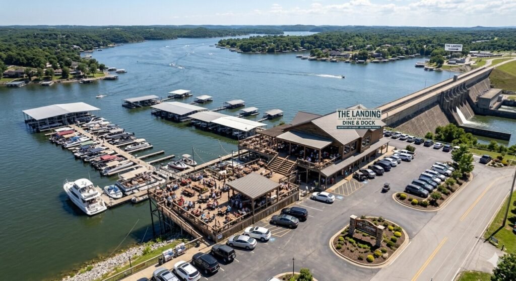
As you cruise the main channel, waterfront dining is one of the biggest draws along this route. Many lake area visitors and residents prefer to visit their favorite restaurants and nightclubs by boat, and with more than 40 establishments on or overlooking the water, there are plenty to choose from. You can pull up by boat, tie off at the dock, walk straight to a table, and enjoy a meal right on the water before continuing your trip. Spots like Redhead Lakeside Grill and Dog Days Bar and Grill are well-known stops that boaters love on this stretch.
The scenery itself changes as you travel south. Near the dam, the terrain feels more rugged and dense. As you move further down the channel toward Osage Beach, the shoreline opens into a mix of limestone bluffs, tree lined coves, and resort-dotted banks. On a clear summer day, the water is blue and the skies are wide. It is exactly the kind of lake view that makes people fall in love with the Ozarks.
Tips for a Safe and Smooth Water Journey
Knowing the route is one thing. Making sure your trip goes smoothly is another. A few simple tips will make your Bagnell Dam to Osage Beach boat journey enjoyable from the moment you push off to the moment you dock.
Always download or carry a lake map before you leave. The Lake of the Ozarks mile marker map is available from the Convention and Visitors Bureau and from most rental companies. Having it on your phone or on paper means you always know where you are and what is coming up. A GPS chart plotter is even better for navigating the many coves and side channels along the route without getting turned around.
Watch your speed near marinas, docks, and coves. Missouri law requires idle speed within 100 feet of any dock, occupied anchored boat, or buoyed restricted area. On this route, you will encounter many such areas, especially between mile markers 5 and 20 where development is densest. Pay attention to no wake buoys and slow down well before you reach them.
Keep an eye on fuel. The route from Bagnell Dam to Osage Beach is well served with fuel docks, especially in the 7 to 8 mile marker range. If you are heading out on a full yacht rental and plan to explore beyond Osage Beach, top off your tank before you leave or stop at one of the mid-route fuel docks along the way. Running low on fuel in the middle of a busy summer weekend is a situation you want to avoid.
Check the weather before you go. Lake of the Ozarks can see fast-moving summer storms, and the main channel offers little shelter in rough conditions. Check the forecast before you leave the dock. If afternoon thunderstorms are predicted, plan to be off the main channel by early afternoon or have a marina in mind where you can wait things out safely.
Bring proper ID and your boating credentials. If you were born after January 1, 1984, you are legally required to carry your Missouri boater education card or a valid temporary permit while operating any motorized vessel. The Missouri State Highway Patrol Water Patrol Division actively patrols this section of the lake, especially during peak summer weekends.
Renting a Yacht for This Route
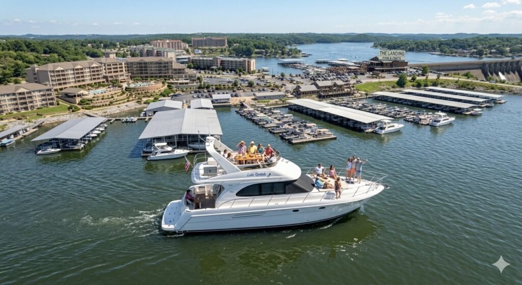
If you do not have your own boat, a yacht rental at Lake Ozark is the best way to experience this route in style. Renting gives you the freedom to cruise at your own pace, stop wherever you like, and enjoy the main channel without any of the logistics of owning and trailering a vessel.
Most yacht rental companies based near the Bagnell Dam and Lake Ozark area can set you up with exactly the right vessel for this kind of trip. A larger pontoon yacht or a luxury cruiser gives you the space to bring your whole group, pack coolers and supplies, and settle in for a relaxed day on the water rather than rushing through the miles. Many rental companies also offer captained charters, which means a licensed captain handles all the navigation while you and your group simply enjoy the experience.
For first-time visitors or anyone unfamiliar with the lake’s layout, a captained charter makes this particular route especially enjoyable. Your captain knows every mile marker, every no wake zone, every waterfront restaurant worth stopping at, and every cove that offers a quiet anchorage. You get local knowledge baked right into your trip, which makes a noticeable difference on a lake this large and this busy.
Frequently Asked Questions
How far is it from Bagnell Dam to Osage Beach by water?
The distance along the main channel from Bagnell Dam at Mile Marker 0 to the Osage Beach area is roughly 14 to 21 miles, depending on where exactly you plan to dock in Osage Beach. The city of Osage Beach sits where the southeastern Grand Glaize arm connects to the main channel, and most marinas and dining spots in that area fall within the mile marker 14 to 21 range.
How long does it take to boat from Bagnell Dam to Osage Beach?
At a comfortable cruising speed of around 20 mph, allowing for no wake zones and moderate traffic, the trip typically takes between 45 minutes and one hour. On a quiet weekday with clear water, you might cover it in 30 to 40 minutes. On a peak summer weekend with heavy boat traffic, plan for a bit longer and enjoy the scenery along the way.
Do I need a boating license to make this trip on a rental yacht?
If you were born after January 1, 1984, you need a Missouri boater education card or a valid temporary permit to legally operate any motorized vessel on the lake. If you were born on or before that date, no license or card is required. Another option is to book a captained yacht charter, in which case the licensed captain handles all operation and no personal credentials are needed.
Can I stop and eat somewhere by boat along the route?
Absolutely. This is one of the best parts of this route. There are more than 40 waterfront restaurants and bars accessible by boat along the Lake of the Ozarks, with a high concentration of them between Bagnell Dam and Osage Beach. Many have their own docks where you can tie up and walk straight to a table. Redhead Lakeside Grill and Dog Days Bar and Grill are two popular stops on this stretch.
What is the mile marker system on Lake of the Ozarks?
Mile markers are numbered reference points along the shoreline of the lake. Mile Marker 0 starts at Bagnell Dam and the numbers increase as you travel south along the main Osage channel. Every marina, restaurant, resort, and waterfront property uses this system to communicate location. When a business says they are at the 17 mile marker, they mean 17 miles along the main channel from Bagnell Dam.
Is the water route from Bagnell Dam to Osage Beach safe for beginners?
Yes, this is one of the more navigable stretches on the lake because the main channel is wide, well marked, and heavily traveled. Fuel docks and marinas are plentiful along the route. That said, beginners should stay alert to boat traffic, observe all no wake zones, and carry a lake map or GPS device. A captained rental is also an excellent option for first-time lake visitors.
What should I bring on a yacht for this route?
Pack sunscreen, a hat, and plenty of water since sun exposure on the lake is intense, especially during summer. Bring your boating credentials, a valid photo ID, a lake map or GPS, a fully charged phone, and snacks or cooler supplies if you plan to spend time anchored in a cove. Life jackets are provided by most rental companies, but confirm this when you book.
When is the best time to make this boat trip?
Early mornings on weekday summer days offer the smoothest and most relaxed experience, with lighter traffic on the main channel. Weekday afternoons are also good. Weekend mornings can be enjoyable but traffic builds quickly by midday. Peak summer weekends around Fourth of July are the busiest on the lake, which can make the main channel feel congested but also incredibly lively if you enjoy the energy of a full lake day.
Final Thoughts
Getting from Bagnell Dam to Osage Beach by water is not just a practical way to travel between two points on the Lake of the Ozarks. It is one of the most enjoyable boat trips you can take on the entire lake. The route follows the heart of the main channel, passing through Missouri’s most active and scenic stretch of recreational water.
Whether you rent a self-drive pontoon yacht, book a captained charter, or come with your own vessel, this route delivers exactly what a great lake day is supposed to feel like. Know your mile markers, respect the no wake zones, fuel up when you have the chance, and take your time. The lake rewards those who slow down and pay attention to everything around them.