
Lake of the Ozarks is not a simple flat-bottomed reservoir. It has dramatic depth variations across its 54,000 acres of surface water. Some sections plunge over 130 feet deep. Others go completely dry when water levels drop even slightly. Knowing where the deep water channels run is not just useful knowledge. For large vessel operators, it is a navigation necessity.
Understanding the deep water channels at Lake of the Ozarks helps you plan safer routes, choose better anchoring spots, avoid running aground, and get far more out of your time on this lake. This guide gives you a comprehensive breakdown of where the deep water is, how the channel system works, what the depth variations mean for different vessel types, and how to read available resources to navigate confidently on this lake.
How the Lake of the Ozarks Was Formed and Why Depth Varies So Dramatically
To understand the deep water channels, you need to understand how this lake was created. Lake of the Ozarks was formed in 1931 when Union Electric completed Bagnell Dam across the Osage River. The rising water flooded the original river valley along with all the tributary streams, hollows, and surrounding terrain.
That flooding of a natural river valley is exactly what creates the dramatic depth variation this lake is known for. The original Osage River channel became the deepest part of the lake. It was the lowest point in the valley before the dam was built. Water carved that channel over thousands of years. When the valley flooded, that original river bed became the deep main channel that runs the length of the lake today.
The surrounding hillsides, ridges, and upland areas that were flooded became the shallower sections. Cove interiors, upper arm sections, and areas away from the original river channels tend to be significantly shallower. In many cove interiors, the bottom rises to less than 5 feet of depth. Flooded timber stumps, old fence lines, and submerged road infrastructure exist in some shallower sections. These hazards are not always marked and can damage propellers and lower units on vessels that stray out of the deep channel without checking depth.
Tributary streams that fed the original Osage River created the arms of the lake. The Niangua River became the Niangua Arm. Various other smaller streams created smaller fingers and coves. Each of these tributary channels has its own depth profile that generally follows the pattern of the main channel system. Deeper water runs along the original stream beds. Shallower water exists at the edges and in the upper reaches of each arm.
This geological history is the key to reading the lake’s depth. Follow the original river and stream channels and you follow the deep water. Move away from those channels toward the former uplands and the bottom rises quickly.
The Main Channel | Where the Deepest Water Runs
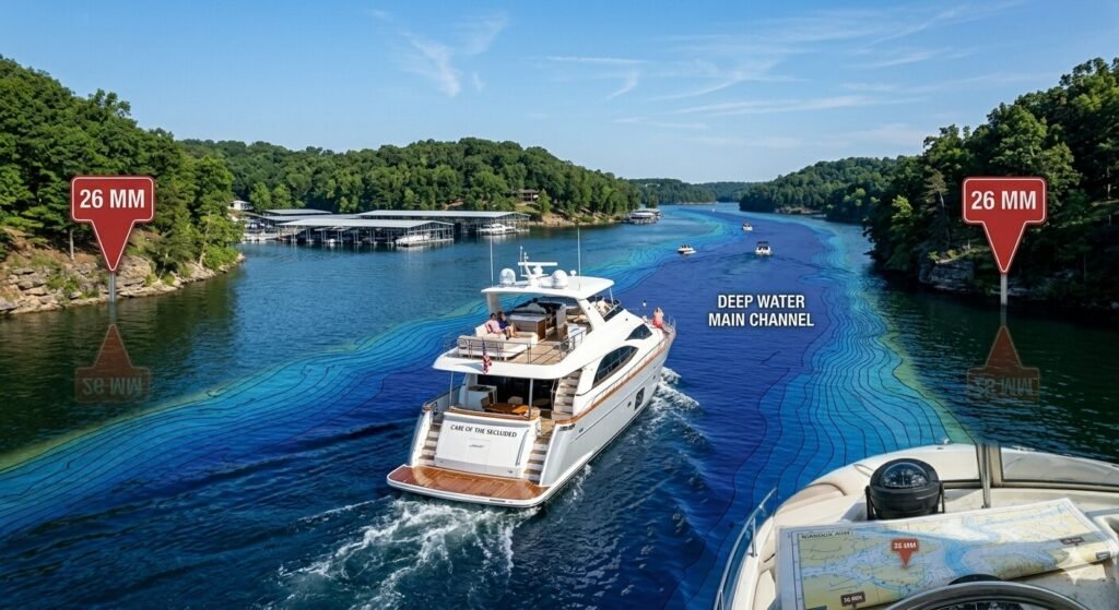
The main channel of Lake of the Ozarks follows the original path of the Osage River from Bagnell Dam northward through the mid-lake region and into the upper lake. This is consistently the deepest section of the entire lake.
Near Bagnell Dam at Mile Marker 0, the main channel reaches its maximum depth. The water directly behind the dam plunges to depths exceeding 130 feet in the deepest sections. This extraordinary depth near the dam is a result of the original river channel combined with the hydraulic scouring effect of water flowing through the dam structure over decades. For reference, 130 feet of water depth is roughly equivalent to a 13-story building submerged beneath the surface. It is genuinely deep water by any measure.
As you move up the main channel away from the dam, depth gradually decreases but remains substantial throughout the lower and mid-lake sections. The main channel through the Mile Marker 1 through 20 range maintains depths generally between 50 and 100 feet in the channel itself. These are very comfortable depths for any vessel operating on this lake including large yachts drawing 4 to 5 feet of water.
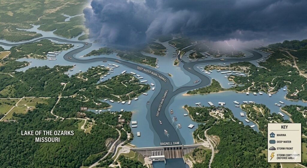
The mid-lake section near Osage Beach from approximately Mile Marker 19 through Mile Marker 28 continues with a well-defined deep channel. This section sees the heaviest recreational boat traffic on the entire lake. The main channel remains deep and well-defined through the Osage Beach corridor. The Grand Glaize Arm branches off in this area and carries its own deep channel following the original Grand Glaize Creek bed.
Party Cove near Mile Marker 28 sits adjacent to the main channel. The channel itself remains deep at this location. However, the cove interior where boats anchor during weekend gatherings is considerably shallower. Most of the anchoring area in Party Cove ranges from 8 to 20 feet. This is adequate for most vessels but operators of larger yachts need to use their depth finder and choose anchoring positions in the deeper sections of the cove interior rather than the shallowest areas near the far end.
As the main channel continues into the upper lake beyond Mile Marker 30, depth remains meaningful along the channel itself but the margins narrow. The original river valley becomes less pronounced in the upper lake. The channel is still clearly defined and navigable for properly sized vessels, but the shallow water on either side of the channel becomes more immediately proximate. In the upper lake sections approaching Mile Marker 40 and beyond, depth finder use becomes increasingly important for any vessel with meaningful draft.
The Niangua Arm and Upper Lake Arms | Depth Profiles You Need to Know
The Niangua Arm is the second most significant deep water channel on Lake of the Ozarks after the main channel. It branches off the main lake in the upper mid-lake area and extends northward following the original path of the Niangua River.
The entrance to the Niangua Arm from the main lake carries reasonable depth along the original river channel. As you travel up the Niangua Arm, depth generally follows the same pattern as the main lake. The deepest water runs along the former river channel in the center of the arm. Shallower water exists at the margins and in the coves branching off the arm.
The upper Niangua Arm becomes progressively shallower as you approach its northern extent. This is characteristic of all tributary arms on Lake of the Ozarks. The further you go from the original confluence with the main Osage River channel, the less depth you can rely on finding in the channel. For large vessels with significant draft, the upper Niangua Arm requires careful depth monitoring. Vessels drawing more than 3 feet should approach the upper sections of any arm with active depth finder attention and reduced speed.
The Grand Glaize Arm near Osage Beach follows the original Grand Glaize Creek channel. It carries usable depth for recreational vessels through most of its navigable length. The Grand Glaize Bridge is a well-known landmark in this arm and sits over water that maintains adequate depth for most recreational boats beneath it. The upper reaches of the Grand Glaize Arm become shallower in its interior sections.
Gravois Mills sits near the entrance to the Gravois Arm, which follows the original Gravois Creek drainage. This arm is popular with boaters looking for quieter anchorage away from main lake traffic. The Gravois Arm carries good depth along its channel for recreational vessels. Like all the arms, the upper interior sections are shallower and require more careful navigation for vessels with significant draft.
The Hurricane Deck area in the upper main lake section offers some of the most scenic and deepest water available for anchoring in the upper lake. The main channel maintains meaningful depth through this section. The bluff-lined coves near Hurricane Deck often drop quickly from the shoreline due to the steep terrain that was flooded when the lake formed. Many of these bluff coves have 20 to 40 feet of depth immediately off the bluff face, which makes them excellent anchoring locations for overnight stays.
Reading Available Depth Charts and Navigation Resources for Lake of the Ozarks
No guide replaces actual navigation tools. Understanding what resources are available and how to use them is essential for anyone planning to navigate Lake of the Ozarks in a vessel with meaningful draft.
NOAA nautical charts cover Lake of the Ozarks as an inland waterway. These charts show the general layout of the lake, approximate depth contours, and navigation hazards. They are a useful baseline reference but they do not capture the detail and real-time accuracy that modern electronic tools provide. NOAA charts are available online and through marine chart services. They provide a useful overview of the lake’s depth profile.
The Army Corps of Engineers publishes lake level information for Lake of the Ozarks regularly. Current lake level is critical context for interpreting any depth chart because all depths on the lake are relative to a standard pool level. When lake level is above normal pool, areas that are marginal at standard pool become more accessible. When lake level is below normal pool, areas that are safely navigable at standard pool may become hazardous. The Army Corps of Engineers’ Truman Dam operations affect Lake of the Ozarks water levels. Check current pool level data before any trip where draft and shallow water are concerns.
Electronic chart plotters and GPS navigation devices with Lake of the Ozarks chart data loaded are the most practical navigation tool for real-time depth awareness. Modern chartplotters overlay depth contours on a moving map display that shows your vessel position relative to channel boundaries, depth contour lines, and known hazards. Quality brands like Garmin, Humminbird, and Lowrance all produce units with freshwater lake chart packages that cover Lake of the Ozarks.
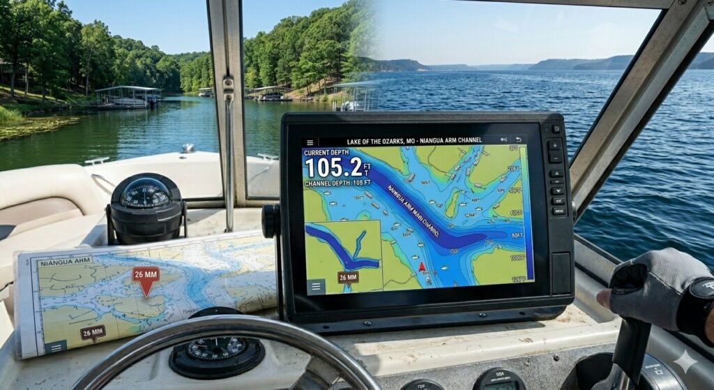
Depth finders and fish finders are indispensable for active depth monitoring while underway on Lake of the Ozarks. A quality depth sounder gives you real-time bottom depth beneath the transducer continuously as you move through the water. This real-time information is more immediately valuable than any chart when you are navigating in an unfamiliar cove or approaching a shallower section of an upper arm. Every serious boater on Lake of the Ozarks should have a functioning depth finder and should actively monitor it whenever operating outside the well-known deep channel sections.
Lake of the Ozarks specific navigation apps for smartphones have improved significantly in recent years. Apps that incorporate local boating knowledge, mile marker references, and depth information for this specific lake give visitors a practical and accessible navigation resource. While smartphone apps should not replace dedicated marine electronics, they provide useful supplemental information especially for trip planning before you leave the dock.
Local marina staff and experienced captains remain among the most valuable navigation resources available. Someone who has been operating on Lake of the Ozarks for multiple seasons knows which cove entrances have submerged obstacles. They know which upper arm sections have become shallower due to siltation. They know where the best deep water anchoring is for a vessel your specific size. That local knowledge fills gaps that no chart or app completely covers.
Shallow Water Hazards and Areas to Approach with Caution
Understanding where the deep water is naturally requires understanding where the shallow water is. Lake of the Ozarks has specific areas and conditions that create grounding risk for vessels that are not paying attention.
Cove interiors and upper reaches are consistently the shallowest sections on the lake. The further you penetrate into any cove beyond its entrance, the more likely you are to encounter shallow water. Coves that look substantial at their entrance can end in 2 to 3 feet of water at their far interior. For a pontoon or small recreational boat this is often manageable. For a vessel with 4 feet of draft, approaching the interior of an unfamiliar cove without depth finder guidance is a genuine grounding risk.
Flooded timber and submerged structure exists in various locations on Lake of the Ozarks particularly in upper lake areas and some cove interiors. When the lake was created in 1931, not all timber was cleared from the flooded land. Some submerged stumps and timber remains in shallower sections. These hazards are not visible from the surface and are not always marked. Propeller strikes on submerged timber are a known hazard on this lake. Slow speed and active depth finder monitoring in unfamiliar cove interiors reduces this risk significantly.
Low water conditions expose hazards that are safely submerged at normal pool. During drought periods or when dam operations draw the lake below normal pool, areas that are routinely navigable at normal levels become inaccessible or hazardous. Rock outcroppings, submerged points, and shallow cove entrances all become more dangerous when lake level is below normal. Always check current pool level from the Army Corps of Engineers before a trip where you plan to navigate in any upper lake arms or cove interiors.
Rock outcroppings and submerged points exist at many cove entrances and along bluff lines throughout the lake. The same geological formations that create the dramatic bluff scenery along sections of the lake also produce submerged rock structures below the waterline. Bluff shorelines that look dramatic and deep immediately at the cliff face may have submerged rock shelves extending outward at various depths. Maintaining adequate distance from bluff shorelines and using your depth finder when approaching unfamiliar bluff lines is the correct approach.
Upper arm sections near their maximum extent are reliably shallower than their lower and mid sections. The Niangua Arm, the Gravois Arm, the Grand Glaize Arm, and every other significant arm on Lake of the Ozarks follows this pattern. The depth at the entrance to each arm from the main lake is almost always greater than the depth at the arm’s furthest navigable extent. As you explore upper arm sections in any vessel with meaningful draft, approach slowly with depth finder active and be prepared to reverse out if depth becomes inadequate.
How Deep Water Knowledge Improves Your Yacht Charter Experience
Understanding the lake’s depth profile directly improves the quality and safety of a yacht charter at Lake of the Ozarks. This knowledge is not just for captains. It benefits guests who want to participate meaningfully in planning their charter experience.
Anchoring decisions are the most immediate way that deep water knowledge improves your day. Choosing an anchoring spot in a cove requires knowing approximately how deep the water is in the area where you want to set the hook. Too shallow and a large yacht risks grounding at any helm input. Too deep and anchor scope requirements become extreme for most charter vessel anchor systems. The sweet spot for overnight anchoring on a large yacht at Lake of the Ozarks is typically 10 to 25 feet of depth in a protected cove setting. That depth range provides adequate holding for a proper anchor setup without requiring an impractical length of rode.
Route planning for large vessels is significantly better when you understand which sections of the lake maintain adequate channel depth for a vessel drawing 4 or more feet of water. A captained charter captain at Yacht Rental Lake Ozark incorporates this knowledge automatically. They plan routes that keep large vessels in the deep channel sections and avoid the marginal depth areas of upper arms and cove interiors where grounding risk exists. Guests who understand this context appreciate why the captain makes certain routing choices that might otherwise seem less direct than expected.
Swimming stops are better chosen with depth awareness. A cove with 15 feet of depth at the anchoring position gives passengers the confidence to swim knowing there is adequate water below them. Anchoring in 5 feet of water and having swimmers jump off the swim platform creates an obvious safety concern. Depth awareness helps the captain select swimming locations that are both safe and enjoyable.
Understanding the relationship between depth and water clarity is a bonus benefit. Deep water sections of Lake of the Ozarks tend to have better water clarity than very shallow sections where sediment is more easily stirred up by boat traffic and wind action. Anchoring in a well-chosen cove with adequate depth typically means cleaner, clearer water for swimming and underwater visibility compared to very shallow interior sections.
Frequently Asked Questions
How deep is Lake of the Ozarks at its deepest point?
The deepest section of Lake of the Ozarks is located near Bagnell Dam at Mile Marker 0. Depth in this section exceeds 130 feet in the main channel adjacent to the dam. This extraordinary depth reflects the original Osage River channel combined with decades of hydraulic scouring from dam operations. As you move up the lake away from the dam, depth gradually decreases but the main channel maintains substantial depth through the mid-lake sections.
Where is the main deep water channel on Lake of the Ozarks?
The primary deep water channel follows the original path of the Osage River from Bagnell Dam northward through the full length of the lake. This is the same route as the navigable main channel that carries primary boat traffic. The deepest water consistently runs along this original river bed. Following the main channel markers and buoys keeps you in the deepest and safest navigable water on the lake.
What is the average depth of Lake of the Ozarks?
The average depth of Lake of the Ozarks is approximately 38 feet across the entire lake surface. However, this average is heavily influenced by the very deep sections near the dam. Many cove interiors and upper arm sections are significantly shallower than this average. The navigable main channel through the mid-lake section maintains depths of 50 to 80 feet in many areas.
Are there depth charts available for Lake of the Ozarks?
Yes. NOAA nautical charts cover Lake of the Ozarks and show general depth contours. The Army Corps of Engineers publishes current lake level data. Electronic chart plotters with Lake of the Ozarks chart packages provide the most practical real-time depth navigation for active boaters. Dedicated depth finders provide real-time bottom depth while underway. A combination of pre-trip chart review and active depth finder use while on the water is the recommended approach for any vessel with significant draft.
Can large yachts navigate the entire Lake of the Ozarks main channel safely?
The main channel through the lower and mid-lake sections is safely navigable for large yachts with typical draft dimensions. The upper lake sections require more careful monitoring and the furthest reaches of some upper arms may not be accessible to vessels drawing more than 2 to 3 feet of water. A professional captain familiar with Lake of the Ozarks knows which sections are safe for a specific vessel’s draft and plans routes accordingly. At Yacht Rental Lake Ozark, our captains incorporate draft-appropriate routing into every charter plan.
How does lake level affect navigable depth at Lake of the Ozarks?
Lake level at Lake of the Ozarks varies based on seasonal rainfall, upstream conditions, and Army Corps of Engineers dam operations. All published depth figures are referenced to a standard pool level. When lake level is above standard pool, additional depth is available in marginal sections. When lake level is below standard pool, sections that are safely navigable at normal levels may become hazardous or inaccessible. Always check current pool level from the Army Corps of Engineers website before a trip where draft and channel depth are significant concerns.
What happens if a yacht runs aground at Lake of the Ozarks?
Running aground on Lake of the Ozarks can range from a minor inconvenience to a serious situation depending on speed, vessel size, and bottom type. At slow speed on a muddy or sandy bottom, grounding is often resolved by reversing throttle to back off the obstruction. At higher speed or on a rocky bottom, grounding can cause significant hull damage including propeller and drive unit damage. Missouri State Water Patrol provides assistance to vessels in difficulty on the lake. Prevention through active depth finder use and conservative navigation in unfamiliar shallow areas is always the correct approach.
Is the deep water channel at Lake of the Ozarks marked with buoys?
The main navigation channel on Lake of the Ozarks is marked with standard lateral buoyage. Red and green channel markers define the navigable channel boundary in areas where channel definition is important. These markers are particularly important in the lower lake near Bagnell Dam and in certain constricted sections of the mid-lake. Following the buoy system in marked sections keeps you in the navigable channel. In open mid-lake sections where the channel is wide and well-defined, formal buoyage is less necessary and the mile marker system provides primary location reference.
What is the best depth for anchoring a large yacht overnight at Lake of the Ozarks?
The optimal anchoring depth for a large yacht overnight at Lake of the Ozarks is typically 15 to 25 feet in a protected cove setting. This depth provides adequate clearance for the vessel’s draft, allows a proper anchor scope of 5:1 to 7:1 without requiring impractical amounts of rode, and ensures the vessel remains safely afloat if any dragging occurs during the night. Protected bluff coves in the upper mid-lake sections around Hurricane Deck offer some of the best combinations of adequate depth and natural protection for large vessel overnight anchoring.
Navigating Lake of the Ozarks with Confidence and the Right Support
Lake of the Ozarks rewards boaters who understand its depth profile. The deep water channels are your safe highways across this lake. The shallower coves and upper arms are beautiful destinations when approached with appropriate speed and active depth monitoring. The dramatic depth variation across this lake is part of what makes it geologically fascinating and visually stunning.
The original Osage River channel that became the lake’s main deep water artery connects Bagnell Dam to the upper lake through more than 40 miles of navigable deep water. The tributary arms that branch off that main channel carry the original stream channels further into the lake’s most scenic and secluded sections. Following those original channels with a functioning depth finder and a current understanding of lake level keeps you in safe water throughout your trip.
For guests who want to experience Lake of the Ozarks without managing the navigation complexity personally, a captained charter with Yacht Rental Lake Ozark puts deep local knowledge of this lake’s depth profile at the helm for your entire experience. Our captains know where the deep water runs. They know the cove entrances that have adequate depth for a large vessel and the upper arm sections that require careful approach. They navigate this lake daily and bring that accumulated knowledge to every charter they operate.
Reach out to Yacht Rental Lake Ozark today. Whether you are planning an exploratory day on the water, an overnight anchoring experience, or a celebration cruise across the best sections of this lake, our team will help you plan the right route on the right vessel with the right captain. The deep water channels of Lake of the Ozarks are waiting. The only thing left is getting out there.