
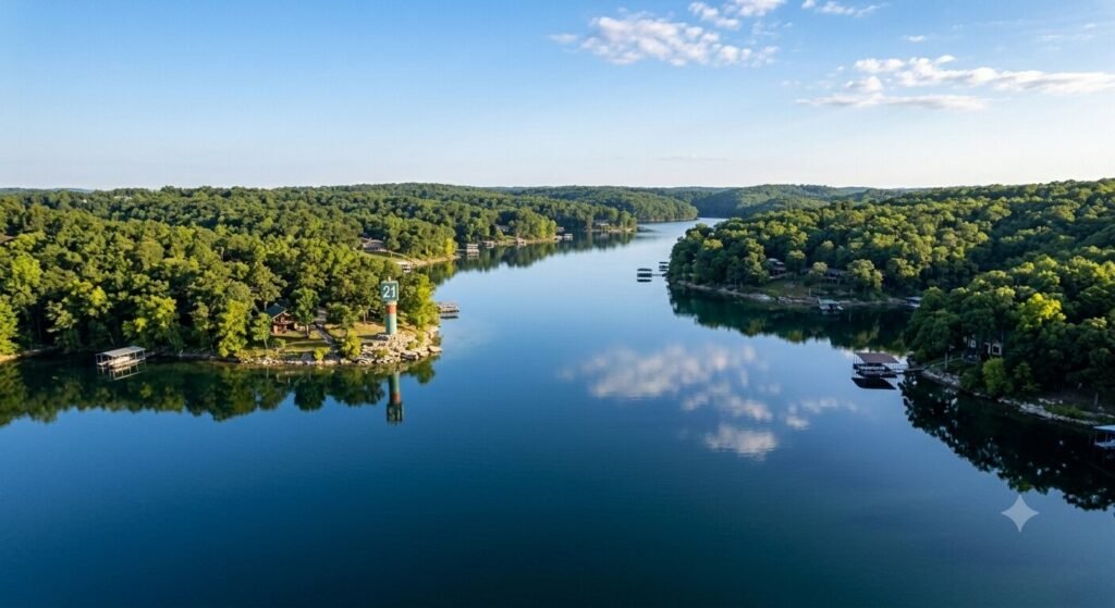
The quiet arms of Lake of the Ozarks are some of the most beautiful stretches of water in Missouri. They offer calm water, stunning scenery, and a peaceful escape from the busy main channel. But these same quiet areas carry some of the highest risks for underwater hazards. The water looks calm on the surface. What lies beneath is a different story entirely.
Submerged stumps, rock ledges, sandbars, and shallow shelves hide in these arms. They have ended boating trips, damaged hulls, and bent propellers for decades. Knowing how to read the water and recognize warning signs before you reach a hazard is one of the most valuable skills any boater can develop on this lake.
This guide gives you everything you need. It covers why quiet arms are more hazardous, how to read water visually, what tools help you navigate safely, and how experienced captains manage these challenges every single day.
Why Quiet Arms Hide More Hazards Than Open Water
It might seem counterintuitive. The busiest parts of the lake feel more dangerous. But the quiet arms of Lake of the Ozarks actually concentrate underwater hazards in ways the main channel does not.
The lake was created by flooding. When Bagnell Dam was completed in 1931, the rising water covered an entire landscape. Forests, farmland, roads, and structures all went underwater. The main channel was dredged and maintained over time. The quiet arms were not. What was once dry land with trees, rock formations, and uneven terrain became the lake bottom. Much of that original terrain is still there.
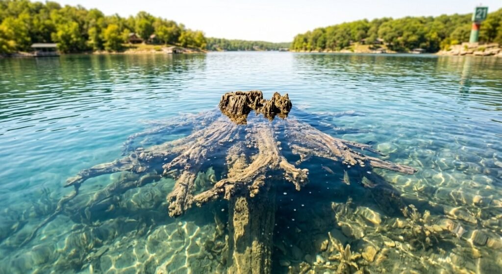
Stumps are everywhere in the arms. Trees were cut before the water rose, but root systems and low stumps remained. Over decades, some have deteriorated. Others remain solid just below the surface. In shallow arms, these stumps sit close enough to the surface to catch a propeller or crack a hull. They are invisible from the surface on a calm day. Only discoloration, turbulence, or experience reveals their location.
Water levels change constantly. Lake of the Ozarks is a managed reservoir. The Army Corps of Engineers and Ameren Missouri control water levels throughout the year. Winter drawdowns lower the lake significantly. Spring refill raises it. Summer levels fluctuate with rainfall and management decisions. A rock shelf that sits safely below your hull at full pool can be a collision risk when the lake drops just two feet. Boaters who learned an arm at one water level can still find hazards when levels shift.
Sedimentation builds shallow areas over time. Silt and organic material settle in the slower-moving water of quiet arms. This gradually builds up the bottom in certain areas. A spot that was five feet deep ten years ago may now be three feet deep. Charts and maps can become outdated. Local knowledge and real-time observation remain the most reliable tools available.
Boat traffic does not clear the way for you. On the main channel, heavy traffic through consistent paths keeps common routes relatively predictable. In quiet arms, there is no such clearing effect. You may be the first boat through a particular section on any given day. There is no guarantee that the path ahead is clear.
Reading the Water Surface | What to Look For
Your eyes are your first and most powerful hazard detection tool. Learning to read the surface of the water accurately can prevent most hazard encounters in quiet arms.
Water color tells you a great deal about depth. Deep, open water appears dark blue or dark green on a clear day. As depth decreases, the color shifts. Lighter green water typically indicates shallower depth. Yellow-green or brown-tinted water near a shoreline or cove entrance is a strong warning sign. The lighter the color, the shallower the water and the more cautious you should be.
Flat spots in moving water signal something beneath the surface. When water flows over a submerged object, it creates a slight disturbance on the surface. You may see a small ripple, a swirl, or a flattened patch that does not match the surrounding water texture. These subtle signs are easy to miss at speed. Slowing down dramatically increases your ability to spot them before you reach them.
Discoloration around stumps is often visible. A submerged stump creates a slightly darker circle or shadow on the lake bottom that you can sometimes see through the water. In clear, shallow water, this shadow appears as a brownish or dark spot below the surface. It may not look exactly like a stump. It looks like something is there. That is enough of a signal to steer around it.
Debris on the surface indicates shallow or active bottom areas. Floating sticks, bark fragments, and vegetation near the surface often come from the bottom in shallower sections. When you see organic debris gathering on the surface in a particular area, it suggests that the bottom is not far below. Treat that area with caution until you have confirmed the depth.
Bird behavior can indicate shallow water too. Herons, egrets, and other wading birds stand in shallow water. If you see birds standing in what appears to be open water, that area is extremely shallow. Steer well clear of any area where birds are standing on what looks like the lake surface.
Using Depth Finders, Charts, and Navigation Tools
Visual reading of the water is essential. But it works best when combined with the right tools. Experienced boaters and captains use several resources together to stay safe in quiet arms.
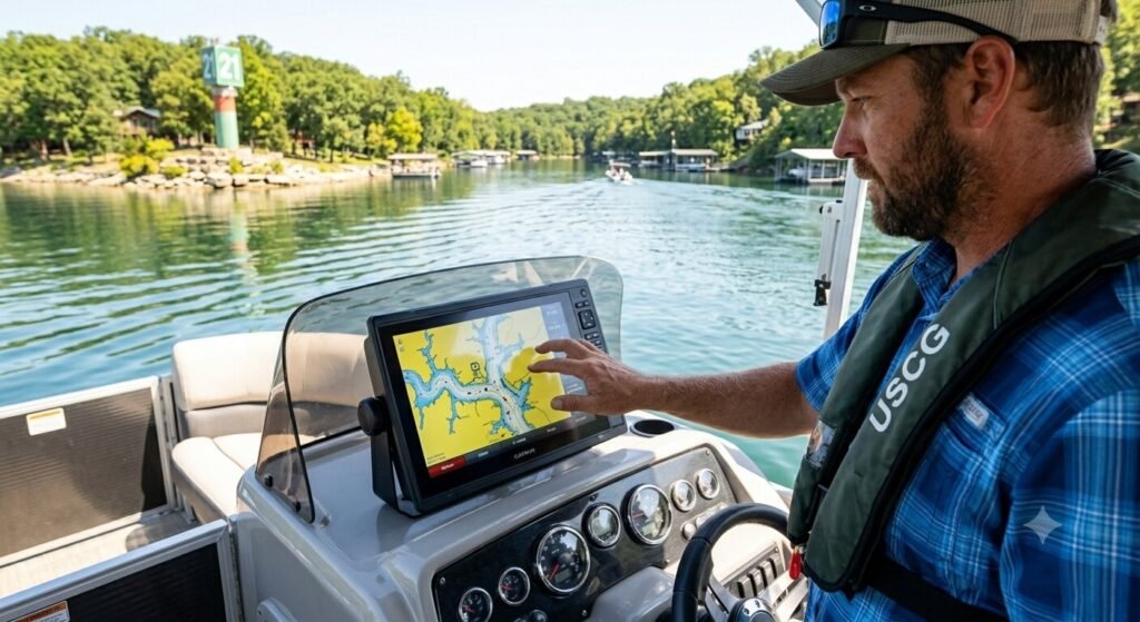
A quality depth finder is one of the most important tools on any boat. Modern depth finders display real-time bottom readings as you move through the water. They show you the depth directly below your hull at any given moment. Some advanced units display a cone of depth readings around the vessel. A depth finder will not show you what is ahead of you, but it gives you continuous awareness of what is directly below. If the numbers are dropping fast, you slow down immediately.
Nautical charts for Lake of the Ozarks provide a baseline map of the lake bottom. These charts show known depths, marked hazards, shallow areas, and channel boundaries. They are not perfectly current because the lake bottom changes. But they are invaluable as a starting reference. Study the chart before entering an unfamiliar arm. Know where the historically shallow sections are before you get there.
GPS chartplotters combine digital maps with your real-time position. They allow you to see your exact location overlaid on a lake chart at all times. This is especially useful in arms that curve and branch. Without a GPS reference, it is easy to misjudge your position and drift toward a known hazard area. A chartplotter keeps your position visible at all times.
Smartphone apps like Navionics and Lake Master provide updated lake charts on mobile devices. These apps are widely used by Lake of the Ozarks boaters. They include user-contributed hazard reports in some versions, which adds a layer of real-world current information beyond what official charts provide. Download your charts for offline use before leaving the dock. Cell coverage in quiet arms can be inconsistent.
Local marinas and dock operators are an underused resource. The people who work on this lake every day know where the current hazards are. They know which arms have had recent low water exposure. They know where stumps have caught boats recently. A quick conversation with marina staff before heading into an unfamiliar arm can save you significant trouble. Never skip this opportunity when exploring a new section of the lake.
Speed, Positioning, and Approach Techniques in Quiet Arms
Knowing hazards exist is one thing. Navigating safely through areas where they might be present is another. Technique matters enormously in quiet arms.
Slow down before you need to. The faster you are moving when you encounter a hazard, the less time you have to react. In quiet arms where hazards are more common, a slower baseline speed is simply the right approach. This is not just about safety. It is about giving yourself options. A boat moving at 7 miles per hour can stop or turn much more effectively than one moving at 20.
Stay in the center of the arm where possible. The deepest water in most arms runs through the middle. Shorelines and coves are where shallow water, stumps, and rock shelves accumulate. Hugging the center gives you the best chance of staying in deeper, clearer water. As you approach a cove or a bend, slow down further. Depth and hazard conditions at bends are often unpredictable.
Watch the angle of sunlight carefully. Sunlight directly overhead creates the clearest view of the water below. When the sun is low on the horizon, glare makes it nearly impossible to see anything beneath the surface. Early morning and late afternoon boating in quiet arms requires extra caution because of this glare effect. Polarized sunglasses reduce glare significantly and improve your ability to see through the water surface at any time of day.
Post a lookout when entering unknown areas. On a charter vessel with multiple passengers, assigning one person to watch the water ahead is a practical safety measure. A second set of eyes scanning the surface ahead of the bow catches things the captain may miss while managing the vessel. This simple step has prevented countless hazard encounters on the lake.
Make gradual turns rather than sharp ones when navigating arms. A sharp turn brings the stern out wide and can sweep the propeller across shallow water that the hull cleared safely. Gradual, controlled turns keep the entire vessel on a more predictable path through the water.
Specific Hazard Types in the Arms of Lake of the Ozarks
Each type of underwater hazard behaves differently and requires a slightly different response. Understanding what you are looking for makes spotting it faster and more instinctive.
Submerged stumps are the most common hazard in the quiet arms. They vary widely in size and depth. Some sit just inches below the surface. Others are two or three feet down. In clear, shallow water they may be faintly visible as dark shapes. In murky or tannin-colored water they are invisible until contact. Stumps are most prevalent near former forest areas along the Niangua Arm, Big Niangua Arm, and Upper Osage Arm. These arms retained more of their original tree cover before flooding and have historically higher stump concentrations.
Rock ledges and submerged boulders appear primarily near the limestone bluffs that characterize parts of the lake’s shoreline. These formations do not give visual warning in the same way stumps do. The water surface above a submerged rock ledge looks identical to the water surface above open depth. Depth finders are the most reliable detection tool for rock hazards. If you are near a bluff shoreline and your depth finder shows a sudden sharp rise in the bottom, steer away immediately.
Sandbars and silt shelves accumulate at cove entrances and at points where tributaries enter the arms. Where moving water slows, it drops the sediment it carries. This creates gradual buildup that extends outward from shorelines. Sandbars often have a distinct color change visible from above. The water over them appears lighter and sometimes slightly murky compared to the surrounding clearer water. These are forgiving hazards compared to stumps and rocks, but they can still ground a vessel firmly and cause propeller damage.
Floating debris after rain events presents a different kind of hazard. Heavy rain washes branches, logs, and trash into the lake from tributary streams. This debris enters the quiet arms and can sit just below the surface. After any significant rainfall, increase your vigilance dramatically. Partially submerged logs are among the most damaging hazards a boat can strike because they carry significant mass and are nearly invisible until you are right on top of them.
How USCG-Certified Captains Navigate Hazardous Arms
When you book a captained charter with Yacht Rental Lake Ozark, navigating hazardous arms is handled by someone who does it professionally. Understanding what your captain does gives you confidence in the experience and insight into the skills involved.
Experienced captains study current water levels before every trip. They check the lake level against known charts. When levels are lower than normal, they identify which arms are most affected and adjust routes accordingly. This pre-trip assessment is something most recreational boaters skip entirely.
They use multiple tools simultaneously. A good captain does not rely on just the depth finder or just the chart. They watch the water visually, monitor the depth finder continuously, reference GPS position, and draw on their accumulated local knowledge all at the same time. This layered approach catches hazards that any single method would miss.
Captains who know Lake of the Ozarks well have mental maps built from hundreds of trips through the same arms. They know where stumps have been reported. They know which cove entrances run shallow. They know which bluff sections hide rock shelves at lower water levels. This knowledge base is simply not something a chart or app can fully replicate. It comes from time on the water.
They communicate hazard areas to passengers proactively. A good captain does not wait until the situation is tense to explain what is happening. When approaching a section that requires careful navigation, they let passengers know. That transparency builds trust and keeps everyone calm if a course change or speed reduction is needed unexpectedly.
Choosing a captained yacht or tritoon charter through Yacht Rental Lake Ozark means all of this expertise is part of your experience from the moment you leave the dock. You enjoy the scenery. Your captain manages the navigation.
Frequently Asked Questions
What are the most hazardous quiet arms on Lake of the Ozarks for underwater obstacles?
The Niangua Arm, Big Niangua Arm, and Upper Osage Arm have historically higher concentrations of submerged stumps due to the original forest cover in those areas before the lake was created. Cove entrances throughout all arms carry sandbar and silt shelf risks. Bluff-lined sections of any arm can hide rock ledges close to the surface. No single arm is entirely free of hazards. Every quiet section of the lake deserves the same cautious approach regardless of which arm you are exploring.
How much does water level change affect underwater hazard risk?
Water level changes have a significant impact. The lake can drop several feet during winter drawdown managed by Ameren Missouri. A drop of even two feet exposes or brings closer to the surface many hazards that are safely submerged at full pool. Rock ledges, stumps, and sandbars that posed no risk at summer levels can become serious obstacles at lower water. Always check the current lake level before your trip and compare it to the level at which your chart data was collected.
Are depth finders accurate enough to rely on completely in quiet arms?
Depth finders are highly valuable but should never be your only tool. They show the depth directly below the transducer, which is typically mounted at the stern. They do not show what is ahead of the bow. They also have minimum detection thresholds that can miss very small or narrow objects like individual stumps. Use your depth finder as one part of a layered approach that also includes visual reading of the water, chart reference, and reduced speed in unfamiliar areas.
What should I do if my boat strikes an underwater hazard?
Stop the vessel immediately if it is safe to do so. Check for hull damage and inspect whether water is entering the bilge. Check on all passengers for injuries. If the hull is taking on water, activate your bilge pump and call for assistance immediately. Contact the Missouri State Highway Patrol Water Division or the U.S. Coast Guard if the situation is serious. Even if damage appears minor, have the hull professionally inspected before your next outing. Impact damage is not always visible from inside the vessel.
Can I use satellite imagery to identify shallow areas before a trip?
Yes, and it is a useful supplementary tool. Google Earth and similar platforms provide overhead imagery of the lake at various water levels. In shallow areas, the lighter water color is often visible from above. You can use this imagery to identify cove entrances and arm sections that appear consistently shallow. However, imagery is not real-time and does not replace on-water observation. Use it during your planning phase alongside nautical charts for a better pre-trip picture of the areas you intend to explore.
How do I know if an area I want to anchor in is safe from underwater hazards?
Before anchoring, do a slow pass through the intended area at minimum speed while watching your depth finder carefully. Look for consistent depth readings without sudden rises. Check the water color and clarity for signs of shallow bottom. If possible, use a pole or oar to physically probe the bottom before setting anchor in very shallow or unfamiliar water. Avoid anchoring near visible stumps, close to rocky bluffs, or at cove entrances where silt buildup is common. Your USCG-certified captain will assess all of this before anchoring on a charter trip.
Do underwater hazards change from year to year on Lake of the Ozarks?
Yes, the hazard picture changes continuously. New debris enters the lake after storms. Sedimentation shifts sandbar locations. Fluctuating water levels expose previously submerged hazards or cover ones that were previously visible. Stumps deteriorate over decades but rarely disappear entirely. Rock formations are permanent but their risk level changes with water level. Checking recent boater reports through local marina staff, online boating forums, and fishing communities gives you the most current hazard information available before any trip into the quiet arms.
Is it safe to take children into quiet arms given the hazard risks?
Quiet arms are wonderful for families precisely because of the calm, protected water they offer. The key is appropriate preparation and the right vessel. A captained charter eliminates the navigation burden from you entirely. Your USCG-certified captain manages all hazard avoidance while you focus on your family. Ensure all children wear properly fitted life jackets at all times on the water. Avoid standing near the bow when moving through unfamiliar sections. With these precautions in place, the quiet arms of Lake of the Ozarks are genuinely among the best family boating destinations in the region.
Explore the Quiet Arms Safely with Yacht Rental Lake Ozark
The quiet arms of Lake of the Ozarks offer some of the most rewarding boating experiences on the entire lake. Calm water, natural scenery, and a sense of discovery make these areas special. Navigating them safely simply requires knowledge, the right tools, and a cautious approach.
When you book a captained yacht or tritoon charter with Yacht Rental Lake Ozark, your USCG-certified captain brings all of that expertise to every trip. From the Niangua Arm to the Upper Osage Arm and throughout Camden County waters, your captain knows this lake and navigates it with skill and confidence every single day. Book your charter today and explore the full beauty of Lake of the Ozarks the right way.