
How to Read Mile Markers at Lake of the Ozarks
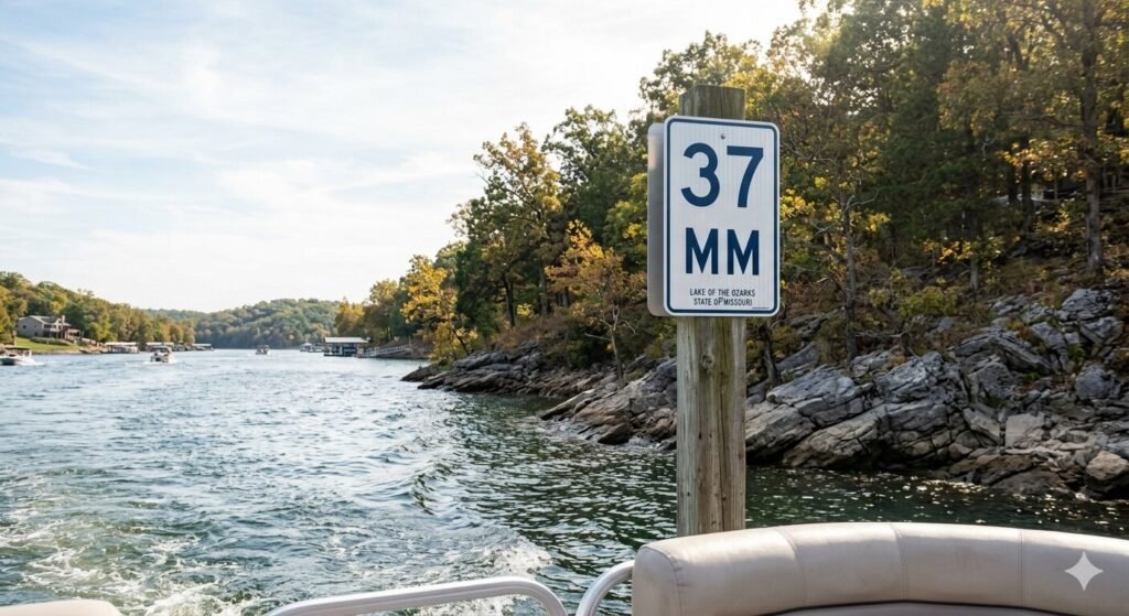
Lake of the Ozarks is one of the most complex recreational lakes in the entire United States. It does not look like a simple oval or rectangle on a map. It looks like a giant tree with a long trunk and dozens of branches spreading in every direction. It winds, splits, bends, and doubles back on itself across more than 1,100 miles of shoreline. For a first-time visitor on the water, that complexity can feel genuinely disorienting. Everything starts to look the same. Coves blend together. The open water stretches in multiple directions. You are not sure if you are heading toward your destination or away from it. That is exactly why mile markers at Lake of the Ozarks exist. They are the lake’s navigation system. Once you understand how they work, everything on the water makes sense. You can find any location, describe any spot to another boater, and navigate this massive lake with real confidence. This guide explains the mile marker system completely. By the end, you will read mile markers like someone who has been on this lake for years. Why Lake of the Ozarks Uses a Mile Marker System Lake of the Ozarks was created in 1931 when Bagnell Dam was completed across the Osage River. The Union Electric Company built the dam to generate hydroelectric power. The resulting reservoir became one of the largest man-made lakes in the United States at the time of its creation. The lake does not have street addresses. There are no intersections, no block numbers, and no street signs on the water. Early boaters, property owners, and marina operators needed a consistent way to describe locations on the lake. A mile marker system was developed to solve that problem. It became the universal reference system that everyone on Lake of the Ozarks uses today. The system is deeply embedded in the culture of this lake. Locals do not say they live near the southern end of the lake. They say they live at mile marker 8. A marina does not advertise its general location. It advertises its mile marker. When a charter captain talks about where Party Cove is, they give you a mile marker. When a lakeside bar like Shady Gators or Backwater Jacks gives directions, mile markers are part of that conversation. Understanding this system is not just useful for navigation. It is the language of Lake of the Ozarks. How the Mile Marker Numbering System Works The mile marker system at Lake of the Ozarks starts at Bagnell Dam and counts outward from there. This is the single most important thing to understand about the system. Everything radiates from the dam. Mile Marker 0 is located at Bagnell Dam itself. This is the lower end of the lake, closest to the dam structure. As you travel away from Bagnell Dam and up the lake toward its upper arms and tributaries, the mile marker numbers increase. The further you get from the dam, the higher the number. The main channel of the lake follows the original path of the Osage River. This is the deepest and widest section of the lake. It runs from Bagnell Dam northward and eventually splits into two major arms. The primary arm continues up the original Osage River path. The secondary arm follows the Niangua River tributary. Both arms have their own mile marker sequences extending from where they branch off the main channel. The main channel reaches into the mid-40s in terms of mile markers before it branches. The Osage Arm and the Niangua Arm each extend further with their own numbering that continues from the split point. The Niangua Arm stretches from approximately Mile Marker 42 at its entrance and runs north. The upper Osage Arm extends into the upper lake regions past the 40s. The numbering on the main channel gives you an instant sense of where you are relative to the rest of the lake. Low numbers mean you are near Bagnell Dam and the lower lake. The areas near Mile Marker 1 through 10 include the commercial hub near the dam, the Lake Ozark city area, and the high-traffic lower lake zone. Mid-range numbers like Mile Marker 20 through 30 put you in the busy mid-lake region near Osage Beach. Higher numbers push you into the quieter upper lake territory. Mile markers are posted on signs visible from the water. They appear on both shorelines at regular intervals. The signs are typically white with black numbers and are mounted on poles or structures along the bank. They are designed to be readable from a boat on the water. As you cruise the main channel, you can track your position by watching these markers appear on the shoreline. The Main Channel vs. the Arms | Understanding the Full System The mile marker system is more than just a single line of numbers from the dam outward. The lake branches into multiple arms and each arm has its own mile marker context. Understanding how the main channel relates to the arms is what takes your navigation from basic to confident. The main channel is the backbone of the lake. It carries the highest boat traffic. It has the deepest water. It connects the lower lake near Bagnell Dam to the mid-lake hub at Osage Beach and beyond. Every major marina, every well-known destination, and every high-traffic area on Lake of the Ozarks has a main channel mile marker reference even if it sits in a cove or off the primary channel. Coves and inlets are referenced by the mile marker at their entrance on the main channel. If a cove opens off the main channel at Mile Marker 18, boaters refer to that as the Mile Marker 18 cove. You do not need a separate addressing system for coves. The mile marker at the cove entrance is the reference point everyone uses. The Niangua Arm branches off the main channel in the upper lake area. This arm extends northward